Approximate Location Map
Large Map »
Latitude: 52.2424 / 52°14'32"N
Longitude: 0.7124 / 0°42'44"E
OS Eastings: 585286
OS Northings: 263935
OS Grid: TL852639
Mapcode National: GBR QF0.6YL
Mapcode Global: VHKD4.9WHV
Plus Code: 9F426PR6+XX
Entry Name: 28 and 29, Guildhall Street
Listing Date: 12 July 1972
Grade: II
Source: Historic England
Source ID: 1363729
English Heritage Legacy ID: 466847
ID on this website: 101363729
Location: Bury St Edmunds, West Suffolk, IP33
County: Suffolk
District: West Suffolk
Civil Parish: Bury St Edmunds
Built-Up Area: Bury St Edmunds
Traditional County: Suffolk
Lieutenancy Area (Ceremonial County): Suffolk
Church of England Parish: Bury St Edmunds St Mary
Church of England Diocese: St.Edmundsbury and Ipswich
Tagged with: Building
BURY ST EDMUNDS
TL8563NW GUILDHALL STREET
639-1/15/374 (East side)
12/07/72 Nos.28 AND 29
GV II
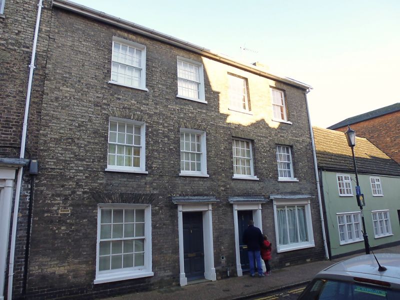
A pair of houses, one with a shop. Early C19 with a C16 core.
Timber-framed core, raised and faced in white brick; slate
roof with a plain wood eaves soffit.
EXTERIOR: 3 storeys. 4 window range: sashes in plain reveals,
16-pane to the 1st and 2nd storeys. No.29 has a small early
C19 shop window with reeded architraves and cornice and C20
plate glass. 2 6-panel doors, partly glazed, have reeded
architraves and small cornices.
INTERIOR: No.29 has an open C16 fireplace on the south side
with a damaged timber lintel and a stone jamb on one side, the
remainder rendered. In the front wall one main post and part
of a middle rail. Ceiling with a small main beam, chamfered,
with scroll stops.
Listing NGR: TL8528663935
External links are from the relevant listing authority and, where applicable, Wikidata. Wikidata IDs may be related buildings as well as this specific building. If you want to add or update a link, you will need to do so by editing the Wikidata entry.


Other nearby listed buildings
