Approximate Location Map
Large Map »
Latitude: 52.2427 / 52°14'33"N
Longitude: 0.712 / 0°42'43"E
OS Eastings: 585257
OS Northings: 263962
OS Grid: TL852639
Mapcode National: GBR QF0.6V7
Mapcode Global: VHKD4.9W8N
Plus Code: 9F426PV6+3R
Entry Name: 72, Guildhall Street
Listing Date: 7 August 1952
Last Amended: 30 October 1997
Grade: II
Source: Historic England
Source ID: 1363708
English Heritage Legacy ID: 466867
ID on this website: 101363708
Location: Bury St Edmunds, West Suffolk, IP33
County: Suffolk
District: West Suffolk
Civil Parish: Bury St Edmunds
Built-Up Area: Bury St Edmunds
Traditional County: Suffolk
Lieutenancy Area (Ceremonial County): Suffolk
Church of England Parish: Bury St Edmunds St Mary
Church of England Diocese: St.Edmundsbury and Ipswich
Tagged with: Building
BURY ST EDMUNDS
TL8563NW GUILDHALL STREET
639-1/15/394 (West side)
07/08/52 No.72
(Formerly Listed as:
GUILDHALL STREET
(West side)
Nos.72 AND 73)
GV II
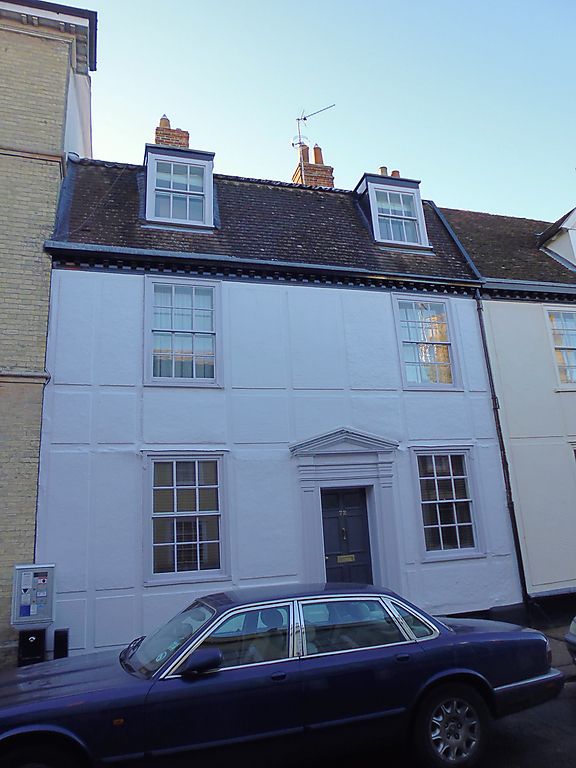
House. C18 front, early C17 and early C19 rear. Timber-framed
and rendered with raised roughcast panels; plaintiled mansard
roof.
EXTERIOR: 2 storeys, attics and cellar. 2 window range:
12-pane sashes in flush cased frames to both storeys. 2
flat-headed lead covered dormers have 6-pane sash windows. A
6-panel door with the top 2 panels glazed, up steps, has a
wood doorcase with plain reveals, panelled pilasters and
pediment. An internal chimney-stack has a plain square red
brick shaft with chimney-pots. A long rear range in 2 phases
of building.
INTERIOR: cellar below whole of front range: walling with some
old flint and render, but mainly C19 brick with various niches
inserted in 2 stages. Timber ceiling, part C18, part with
reused earlier joists. C18 front range in 2 bays with a C20
division into 2 rooms.
All earlier partitions removed, but the present entry,
formerly into a narrow early C19 corridor with a
semicircular-headed rear archway, may well be in the original
position. Fireplace with a mid-C18 eared wood surround. An
early C19 stair has stick balusters, closed strings, rounded
newel posts and a curved handrail.
A C17 2-storey rear wing in 2 bays has the main components and
some studding exposed on the upper storey; roofs covered.
Extending from this wing an early C19 range in flint and brick
with a mansard roof, said to have been used initially as a
corn store.
Listing NGR: TL8525763962
External links are from the relevant listing authority and, where applicable, Wikidata. Wikidata IDs may be related buildings as well as this specific building. If you want to add or update a link, you will need to do so by editing the Wikidata entry.


Other nearby listed buildings
