Approximate Location Map
Large Map »
Latitude: 52.2432 / 52°14'35"N
Longitude: 0.7119 / 0°42'42"E
OS Eastings: 585248
OS Northings: 264026
OS Grid: TL852640
Mapcode National: GBR QF0.6V0
Mapcode Global: VHKD4.9W66
Plus Code: 9F426PV6+7Q
Entry Name: 79, Guildhall Street
Listing Date: 7 August 1952
Grade: II*
Source: Historic England
Source ID: 1363716
English Heritage Legacy ID: 466875
ID on this website: 101363716
Location: Bury St Edmunds, West Suffolk, IP33
County: Suffolk
District: West Suffolk
Civil Parish: Bury St Edmunds
Built-Up Area: Bury St Edmunds
Traditional County: Suffolk
Lieutenancy Area (Ceremonial County): Suffolk
Church of England Parish: Bury St Edmunds St Mary
Church of England Diocese: St.Edmundsbury and Ipswich
Tagged with: Building
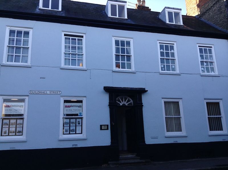
BURY ST EDMUNDS
TL8564SW GUILDHALL STREET
639-1/14/402 (West side)
07/08/52 No.79
GV II*
House, now offices and flats. C18 exterior with partly C12
core. Timber-framed above a plinth of stone blocks; roughcast.
Slate roof with a moulded wood eaves cornice.
EXTERIOR: 2 storeys, attics and cellar; 2 wings at rear. 5
window range: 12-pane to the 1st storey and without glazing
bars on the ground storey, all in heavy flush cased frames. A
central 6-panel door has a semicircular fanlight with radial
glazing bars and a doorcase with panelled pilasters and
cornice.
INTERIOR: cellar below the northern half of the front with
C18/C19 brick walls almost entirely to the south and east, on
the west mixed with areas of flint rubble. The north wall is
of flint rubble with various recesses. C15/C16 bridging beam
to ceiling, probably intended to rest on supporting piers;
C18/C19 joists.
Running through the ground storey from north to south is a
thick wall faced with ashlar blocks along its western face.
This contains a Norman doorway, which is at the back of the
present cross-entry, with a roll-moulded arch; the nook shafts
have capitals with volutes. At the south end of the wall is
another narrow doorway with a chamfered pointed arch, probably
dating from the late C12.
A low round-headed window with a chamfered arch, boarded over,
is half way along the same wall. This wall appears to extend
for the whole length of the building and may have a return
wall on the north between No.79 and No.80 (qv). 2 pairs of
tall timber columns with matching 'Norman' capitals are spaced
along the present cross-entry, one pair immediately inside the
entrance door.
A C17 rear wing on the south has a heavy main beam with large
chamfer and lambstongue stop with quirk and has been extended
into a later bay. A rear wing on the north now forms part of
the adjoining premises and has no exposed original features;
between the 2 wings is a flat-roofed extension containing a
stair with ramped handrail but with boarding covering the
balusters.
Listing NGR: TL8524864026
External links are from the relevant listing authority and, where applicable, Wikidata. Wikidata IDs may be related buildings as well as this specific building. If you want to add or update a link, you will need to do so by editing the Wikidata entry.


Other nearby listed buildings
