Approximate Location Map
Large Map »
Latitude: 51.4811 / 51°28'51"N
Longitude: -1.6183 / 1°37'6"W
OS Eastings: 426599
OS Northings: 175858
OS Grid: SU265758
Mapcode National: GBR 5XY.5N7
Mapcode Global: VHC1J.W1TG
Plus Code: 9C3WF9JJ+CM
Entry Name: Nos 7, 9 and 11 Lottage Road
Listing Date: 6 March 1985
Grade: II
Source: Historic England
Source ID: 1365426
English Heritage Legacy ID: 310508
ID on this website: 101365426
Location: Aldbourne, Wiltshire, SN8
County: Wiltshire
Civil Parish: Aldbourne
Built-Up Area: Aldbourne
Traditional County: Wiltshire
Lieutenancy Area (Ceremonial County): Wiltshire
Tagged with: Building
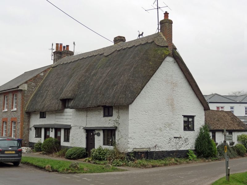
ALDBOURNE LOTTAGE ROAD (west side)
SU 27 NE 9/48
Nos 7, 9 and 11
II
Row of three cottages, now 2. C17-C18. Whitewashed sarsen rubble, thatched roof. 1 storey and attic, 3 bays. One door only to 7 and 9 in centre bay, boarded and glazed panel with bracketed timber roof extended over window, former door, left and to right. Timber casement and some leaded windows. Centre bay weatherboarded at first floor level. Gable stacks and stack to right of centre bay. Single storey rear extension to No. 11 along Goddard's Lane.
Listing NGR: SU2659975858
External links are from the relevant listing authority and, where applicable, Wikidata. Wikidata IDs may be related buildings as well as this specific building. If you want to add or update a link, you will need to do so by editing the Wikidata entry.


Other nearby listed buildings
