Latitude: 51.5214 / 51°31'17"N
Longitude: -1.1364 / 1°8'11"W
OS Eastings: 460011
OS Northings: 180628
OS Grid: SU600806
Mapcode National: GBR 920.FJB
Mapcode Global: VHCZ2.8121
Plus Code: 9C3WGVC7+HC
Entry Name: Elm Cottage
Listing Date: 16 August 1985
Grade: II
Source: Historic England
Source ID: 1368961
English Heritage Legacy ID: 247290
ID on this website: 101368961
Location: Goring, South Oxfordshire, RG8
County: Oxfordshire
District: South Oxfordshire
Civil Parish: Goring-on-Thames
Built-Up Area: Goring
Traditional County: Oxfordshire
Lieutenancy Area (Ceremonial County): Oxfordshire
Church of England Parish: Goring
Church of England Diocese: Oxford
Tagged with: Cottage
GORING STATION ROAD
SU6080 (South side)
Goring-on-Thames
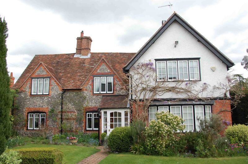
12/73 Elm Cottage
GV II
House. C17 with C19 alterations and extension. Flint with brick dressings; plain
tile roof; brick centre ridge stack. Single storey and attic; 2-window range.
C19 half-glazed door to right. C19 fenestration. Blocked C17 two-light window
with hood mould to gable of left return. Interior not inspected. C19 extension
to right.
Listing NGR: SU6001180628
External links are from the relevant listing authority and, where applicable, Wikidata. Wikidata IDs may be related buildings as well as this specific building. If you want to add or update a link, you will need to do so by editing the Wikidata entry.


Other nearby listed buildings