Approximate Location Map
Large Map »
Latitude: 51.7519 / 51°45'6"N
Longitude: -1.2526 / 1°15'9"W
OS Eastings: 451691
OS Northings: 206179
OS Grid: SP516061
Mapcode National: GBR 8Z4.251
Mapcode Global: VHCXV.77N9
Plus Code: 9C3WQP2W+QX
Entry Name: 3, Kybald Street
Listing Date: 28 June 1972
Grade: II
Source: Historic England
Source ID: 1369677
English Heritage Legacy ID: 245188
ID on this website: 101369677
Location: Oxford, Oxfordshire, OX1
County: Oxfordshire
District: Oxford
Electoral Ward/Division: Holywell
Parish: Non Civil Parish
Built-Up Area: Oxford
Traditional County: Oxfordshire
Lieutenancy Area (Ceremonial County): Oxfordshire
Church of England Parish: Oxford St Mary the Virgin with St Cross with St Peter-in-the-East,
Church of England Diocese: Oxford
Tagged with: Building
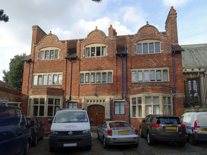
UNIVERSITY COLLEGE
1.
1485
No 3 Kybald Street
SP 5106 SE 9/356K
II
2.
Late Cl9. Red brick with stone dressings. 3 storeys, 3 bays. The ground
floor has a central doorway with canted bays on either side. Above are 4
and 6-light lattice windows. Shaped gables, tiled roof.
Listing NGR: SP5169106179
External links are from the relevant listing authority and, where applicable, Wikidata. Wikidata IDs may be related buildings as well as this specific building. If you want to add or update a link, you will need to do so by editing the Wikidata entry.


Other nearby listed buildings
