Approximate Location Map
Large Map »
Latitude: 53.8206 / 53°49'14"N
Longitude: -1.5796 / 1°34'46"W
OS Eastings: 427770
OS Northings: 436113
OS Grid: SE277361
Mapcode National: GBR B9B.97
Mapcode Global: WHC9C.P7ZF
Plus Code: 9C5WRCCC+64
Entry Name: Headingley Taps Public House
Listing Date: 5 August 1976
Last Amended: 11 September 1996
Grade: II
Source: Historic England
Source ID: 1375262
English Heritage Legacy ID: 466144
ID on this website: 101375262
Location: Headingley, Leeds, West Yorkshire, LS6
County: Leeds
Electoral Ward/Division: Headingley
Parish: Non Civil Parish
Built-Up Area: Leeds
Traditional County: Yorkshire
Lieutenancy Area (Ceremonial County): West Yorkshire
Church of England Parish: Headingley St Michael
Church of England Diocese: Leeds
Tagged with: Pub
LEEDS
SE2736SE NORTH LANE, Headingley
714-1/61/805 (South East side)
05/08/76 Headingley Taps Public House
(Formerly Listed as:
NORTH LANE, Headingley
North Lane Pumping Station)
GV II
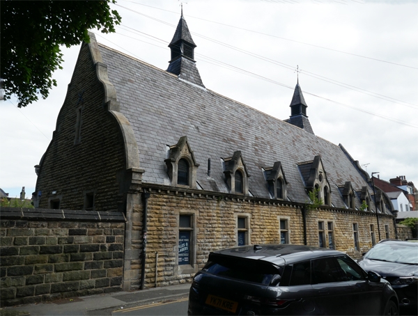
Pumping station, now public house. 1879-80, converted 1993-4.
Built for the Leeds Corporation Waterworks. Rock-faced ashlar,
steep-pitched slate roof. E-plan, the long, lower range
parallel to Bennett Road and 3 gabled wings, the central wing
smaller and recessed, facing the yard on North Lane.
Outer gables: central entrance with boarded door, inscription
over, under hoodmould with coat of arms; flanking tall lancet
windows, a mullion and transom window of 3 stepped lights
above. Dutch gables with finials, missing on right, and
louvred ventilators with pyramidal roof and wrought-iron
finial. The rear 7-window range has shaped dormers and Dutch
end gables.
INTERIOR: not inspected.
The 2 large wings probably housed the pumping engines; the
'lofty chimney' described in 1905 (Kelly) does not survive.
The 1867 Leeds Waterworks Act resulted in the construction of
3 reservoirs in the Washburn valley; 7 filter beds were built
at Weetwood and the water which did not reach the town by
gravitation was brought to the well of the pumping station
from whence it was pumped to the high-service reservoirs at
Moortown and Bramley.
(Fraser, D (Ed): A History of Modern Leeds: Manchester: 1980-:
318; Directory of Leeds: Kelly: 1905-: 5).
Listing NGR: SE2777036113
External links are from the relevant listing authority and, where applicable, Wikidata. Wikidata IDs may be related buildings as well as this specific building. If you want to add or update a link, you will need to do so by editing the Wikidata entry.


Other nearby listed buildings
