Approximate Location Map
Large Map »
Latitude: 53.7925 / 53°47'33"N
Longitude: -1.536 / 1°32'9"W
OS Eastings: 430664
OS Northings: 433010
OS Grid: SE306330
Mapcode National: GBR BLN.M8
Mapcode Global: WHC9D.CXTZ
Plus Code: 9C5WQFV7+2J
Entry Name: Boundary Wall with Gate Piers and Gates to Chadwick Lodge
Listing Date: 11 September 1996
Grade: II
Source: Historic England
Source ID: 1375269
English Heritage Legacy ID: 466154
ID on this website: 101375269
Location: Steander, Leeds, West Yorkshire, LS10
County: Leeds
Electoral Ward/Division: City and Hunslet
Parish: Non Civil Parish
Built-Up Area: Leeds
Traditional County: Yorkshire
Lieutenancy Area (Ceremonial County): West Yorkshire
Church of England Parish: Hunslet St Mary the Virgin
Church of England Diocese: Leeds
Tagged with: Wall
LEEDS
SE3033SE CROWN POINT ROAD
714-1/79/142 (South East side)
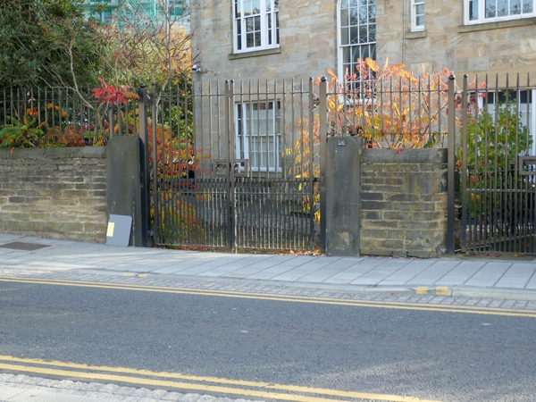
Boundary wall with gate piers and
gates to Chadwick Lodge
GV II
Boundary wall with 2 gateways, gates, steps and wall with
railings. Late C18 and c1843. Coursed squared gritstone,
wrought-iron gates.
Boundary wall fronts Crown Point Road and is approx 20m long
and 1.25m high, with rounded coping stones to left of the
pedestrian gate and flat cap stones to right. The carriage
entrance to Chadwick Lodge has monolithic piers slightly
higher than the walls and with groined tops, 2-leaf gates with
moulded rails, diagonal braces, spearhead finials; the
pedestrian gateway to right has hinge blocks only, gate with
leaf-finials and scrolls to top bar. The pedestrian gate opens
onto a short flight of stone steps with wall topped by railing
to left: alternate straight and wavy bars, moulded standards,
and links to basement wall and railings listed with Chadwick
Lodge.
The boundary of the property was altered when Crown Point Road
was laid out, c1843 and is shown on the OS map of 1847. The
carriage entrance gates and railings are probably contemporary
with the house, late C18, as the railings are similar to the
balustrade to the side entrance steps and the main staircase.
Included for group value.
Listing NGR: SE3066433010
External links are from the relevant listing authority and, where applicable, Wikidata. Wikidata IDs may be related buildings as well as this specific building. If you want to add or update a link, you will need to do so by editing the Wikidata entry.


Other nearby listed buildings
