Latitude: 53.7937 / 53°47'37"N
Longitude: -1.5348 / 1°32'5"W
OS Eastings: 430741
OS Northings: 433141
OS Grid: SE307331
Mapcode National: GBR BLM.VV
Mapcode Global: WHC9D.DXC2
Plus Code: 9C5WQFV8+F3
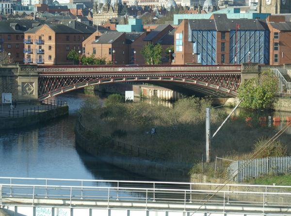
Entry Name: Crown Point Bridge over River Aire
Listing Date: 8 May 1974
Last Amended: 11 September 1996
Grade: II
Source: Historic England
Source ID: 1375272
English Heritage Legacy ID: 466157
ID on this website: 101375272
Location: Steander, Leeds, West Yorkshire, LS10
County: Leeds
Electoral Ward/Division: City and Hunslet
Parish: Non Civil Parish
Built-Up Area: Leeds
Traditional County: Yorkshire
Lieutenancy Area (Ceremonial County): West Yorkshire
Church of England Parish: Richmond Hill, Leeds
Church of England Diocese: Leeds
Tagged with: Road bridge
LEEDS
SE3033SE CROWN POINT ROAD 714-1/79/143 Crown Point Bridge over River Aire 08/05/74 (Formerly Listed as: CROWN POINT ROAD Crown Point Bridge)
GV II
Road bridge. 1842, widened 1994-5 on east side. By George Leather. Stone abutments and road walls, cast-iron arch and parapet with lattice steel work in spandrels. In Gothic Revival style; wide single-span segmental arch, ornate herringbone pattern railed parapet. Abutments have sunk panels with quatrefoil ornament, moulding at road level, pilaster surmounted by lamp standards. Built to carry the road linking Hunslet with the east end of the city, taking its name from the area known as Crown Point Wharf to the west of the bridge; part of the extensive development of the Aire and Calder Navigation at Leeds Lock (qv) since c1820. The bridge was cast at the Park Ironworks, Sheffield, and cost »8,750. (Fraser, D (Ed): History of Modern Leeds: 1980-: 137).
Listing NGR: SE3074133141
External links are from the relevant listing authority and, where applicable, Wikidata. Wikidata IDs may be related buildings as well as this specific building. If you want to add or update a link, you will need to do so by editing the Wikidata entry.


Other nearby listed buildings