Approximate Location Map
Large Map »
Latitude: 53.7925 / 53°47'33"N
Longitude: -1.5328 / 1°31'58"W
OS Eastings: 430875
OS Northings: 433014
OS Grid: SE308330
Mapcode National: GBR BMN.98
Mapcode Global: WHC9D.FXBY
Plus Code: 9C5WQFV8+2V
Entry Name: Aire and Calder Navigation Cut and Locks
Listing Date: 11 September 1996
Grade: II
Source: Historic England
Source ID: 1375056
English Heritage Legacy ID: 465936
ID on this website: 101375056
Location: Steander, Leeds, West Yorkshire, LS10
County: Leeds
Electoral Ward/Division: City and Hunslet
Parish: Non Civil Parish
Built-Up Area: Leeds
Traditional County: Yorkshire
Lieutenancy Area (Ceremonial County): West Yorkshire
Church of England Parish: Hunslet St Mary the Virgin
Church of England Diocese: Leeds
Tagged with: Lock
LEEDS
SE3033SE CLARENCE ROAD
714-1/79/111 (North side (off))
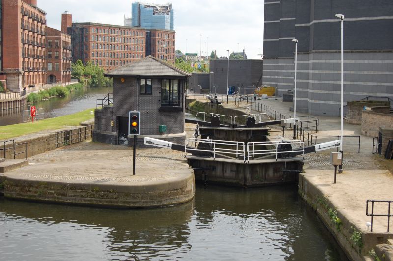
Aire and Calder Navigation Cut and
locks
GV II
Channel cut to allow navigation past the Leeds dam, with 2
sets of locks. Probably c1830-40. By George Leather, engineer,
on the line of the Aire and Calder Navigation Cut of
1699-1700. Stone lining and edges, wood and iron lock gates
and fittings.
Approx 200m long and varying in width from approx 10m to 25m,
parallel lock chambers at eastern end, the narrower northern
lock not in use, gates repaired. Channel to Clarence Dock on
south side, under Clarence Road bridge.
HISTORICAL NOTE: The Aire and Calder Navigation Act was passed
in 1699 and improvements to the river then enabled water-borne
goods to reach the city which until that time depended
entirely on road transport. The development of the riverside
wharves and warehouses dates from that time, with merchants
able to ship cloth directly to Hull and the Continent. For
further historical information, see Basin of New Dock,
Clarence Road (qv).
(Fraser, D: A History of Modern Leeds: 1980-: 119).
Listing NGR: SE3087533014
External links are from the relevant listing authority and, where applicable, Wikidata. Wikidata IDs may be related buildings as well as this specific building. If you want to add or update a link, you will need to do so by editing the Wikidata entry.


Other nearby listed buildings
