Latitude: 53.8002 / 53°48'0"N
Longitude: -1.5507 / 1°33'2"W
OS Eastings: 429689
OS Northings: 433860
OS Grid: SE296338
Mapcode National: GBR BHK.GJ
Mapcode Global: WHC9D.4RT2
Plus Code: 9C5WRC2X+3P
Entry Name: 1, Oxford Place
Listing Date: 22 March 1974
Grade: II
Source: Historic England
Source ID: 1375372
English Heritage Legacy ID: 466268
ID on this website: 101375372
Location: Leeds, West Yorkshire, LS1
County: Leeds
Electoral Ward/Division: City and Hunslet
Parish: Non Civil Parish
Built-Up Area: Leeds
Traditional County: Yorkshire
Lieutenancy Area (Ceremonial County): West Yorkshire
Church of England Parish: Leeds St George
Church of England Diocese: Leeds
Tagged with: Building
LEEDS
SE2933NE OXFORD PLACE 714-1/75/273 (West side) 22/03/74 No.1
GV II
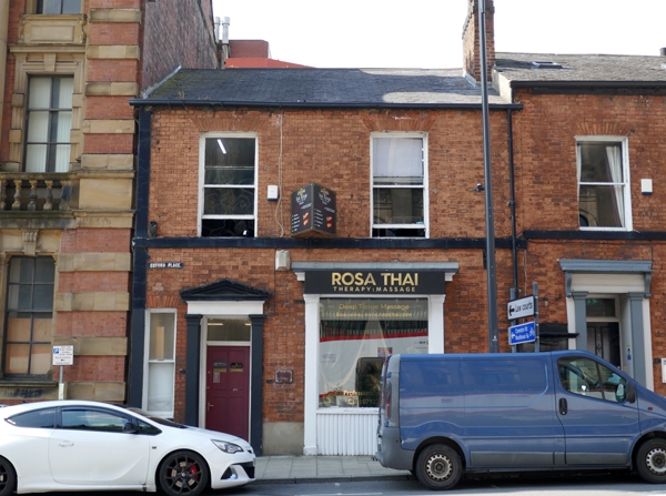
Shop, now offices. Mid C19. Brick, Flemish bond, stone detail, graduated grey slate roof, brick stack forward of ridge right. 2 storeys, 2 bays. Doorcase left with pilasters and entablature with shallow pediment; former shop window right also with pilasters and entablature with cornice. Upper floor: slightly cambered window heads of rubbed bricks, continuous sill band. A narrow inserted window ground floor left was possibly originally a tunnel through to the rear of the premises. INTERIOR: not inspected. J Rapkin's map of Leeds, 1850, shows only the Methodist Chapel in Oxford Place; Brierley's map of 1866 shows the street built up by that date, the small shops facing the new Town Hall. (Rapkin, J: Map of Leeds: 1850-; Brierley, W: Map of Leeds: 1866-).
Listing NGR: SE2968933860
External links are from the relevant listing authority and, where applicable, Wikidata. Wikidata IDs may be related buildings as well as this specific building. If you want to add or update a link, you will need to do so by editing the Wikidata entry.


Other nearby listed buildings