Latitude: 53.1855 / 53°11'7"N
Longitude: -2.8886 / 2°53'18"W
OS Eastings: 340717
OS Northings: 365745
OS Grid: SJ407657
Mapcode National: GBR 7B.36TY
Mapcode Global: WH88F.L6P8
Plus Code: 9C5V54P6+5H
Entry Name: Old Dee Bridge
Listing Date: 28 July 1955
Last Amended: 23 July 1998
Grade: I
Source: Historic England
Source ID: 1375850
English Heritage Legacy ID: 469829
ID on this website: 101375850
Location: Handbridge, Cheshire West and Chester, Cheshire, CH4
County: Cheshire West and Chester
Electoral Ward/Division: Handbridge Park
Parish: Non Civil Parish
Built-Up Area: Chester
Traditional County: Cheshire
Lieutenancy Area (Ceremonial County): Cheshire
Church of England Parish: Chester St Mary without the Walls
Church of England Diocese: Chester
Tagged with: Road bridge
CHESTER CITY (EM)
SJ4065 HANDBRIDGE
1932-1/8/165 Old Dee Bridge
28/07/55
(Formerly Listed as:
Old Dee Bridge)
GV I
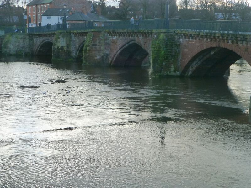
Road bridge over River Dee. Late C14, altered 1826. Red
sandstone. 7 arches, from north to south: a pair of segmental
arches north of diagonal weir; serving leat to former Mills of
Dee then by hydro-electric power station; cutwater at weir,
then plain abutment to first, parabolic, river arch; cutwater;
pointed arch with moulded arris; cutwater; narrower arch with
moulded arris; cutwater; broad segmental arch with moulded
arris; bottom stage forming rectangular projection upstream
for former gate-tower; large cutwater; narrow segmental arch
probably in place of former drawbridge. The bridge was
widened, upstream, in 1826, to provide a footway, partly
corbelled.
The present bridge replaced earlier medieval bridges, probably
of timber, and is believed to stand on the site of a Roman
bridge.
(The Buildings of England: Pevsner N & Hubbard E: Cheshire:
Harmondsworth: 1971-: 157-8; Bartholomew City Guides: Harris
B: Chester: Edinburgh: 1979-: 136).
Listing NGR: SJ4071765745
External links are from the relevant listing authority and, where applicable, Wikidata. Wikidata IDs may be related buildings as well as this specific building. If you want to add or update a link, you will need to do so by editing the Wikidata entry.


Other nearby listed buildings