Approximate Location Map
Large Map »
Latitude: 53.1929 / 53°11'34"N
Longitude: -2.8977 / 2°53'51"W
OS Eastings: 340121
OS Northings: 366578
OS Grid: SJ401665
Mapcode National: GBR 79.2YD2
Mapcode Global: WH88F.G0DK
Plus Code: 9C5V54V2+5W
Entry Name: City Wall from Bonewaldesthorne Tower to Pembertons Parlour
Listing Date: 28 July 1955
Last Amended: 6 August 1998
Grade: I
Source: Historic England
Source ID: 1376130
English Heritage Legacy ID: 470120
ID on this website: 101376130
Location: Chester, Cheshire West and Chester, Cheshire, CH1
County: Cheshire West and Chester
Electoral Ward/Division: Chester City
Parish: Non Civil Parish
Built-Up Area: Chester
Traditional County: Cheshire
Lieutenancy Area (Ceremonial County): Cheshire
Church of England Parish: Chester St John the Baptist
Church of England Diocese: Chester
Tagged with: City walls
CHESTER CITY (IM)
SJ4066NW CITY WALLS
595-1/1/102 City Wall from Bonewaldesthorne
28/07/55 Tower to Pemberton's Parlour
(Formerly Listed as:
City Walls & Towers incl.
foundations of SE angle Roman
Fortress wall & tower)
GV I
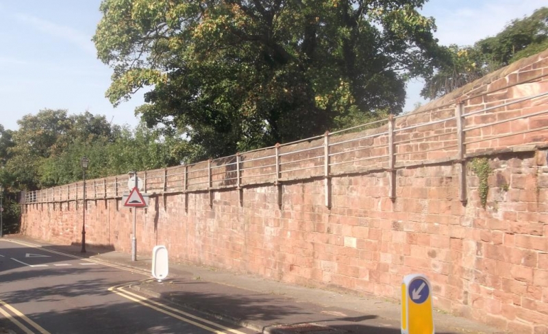
Part of City Walls. Late C11-early C12 origin, altered to form
raised promenade 1701-8; pierced and linked with bridge for
the wall walk 1846 for the Holyhead Railway and with
subsequent repairs. Coursed red rubble sandstone with bridge
of cast-iron. The north, outer, face of the wall has plinth
thrice recessed with weathered caps. The south face is shear.
East of the bridge the earth bank reduces the exposed height
of the wall to 12 courses. Stair C18 or C19 of 34 stone steps
in 3 flights down to Canal Basin, north.
This portion of the wall is 230m long; the wall walk approx 2m
wide.
(Bartholomew City Guides: Harris B: Chester: Edinburgh: 1979-:
94; The Buildings of England: Pevsner N & Hubbard E: Cheshire:
1971-: 155).
Listing NGR: SJ4012166578
External links are from the relevant listing authority and, where applicable, Wikidata. Wikidata IDs may be related buildings as well as this specific building. If you want to add or update a link, you will need to do so by editing the Wikidata entry.


Other nearby listed buildings
