Approximate Location Map
Large Map »
Latitude: 53.1922 / 53°11'31"N
Longitude: -2.8895 / 2°53'22"W
OS Eastings: 340669
OS Northings: 366492
OS Grid: SJ406664
Mapcode National: GBR 7B.2SQN
Mapcode Global: WH88F.L183
Plus Code: 9C5V54R6+V6
Entry Name: Part of City Wall with Tower Base from Kaleyard Gate to Eastgate
Listing Date: 28 July 1955
Last Amended: 6 August 1998
Grade: I
Source: Historic England
Source ID: 1376162
English Heritage Legacy ID: 470156
ID on this website: 101376162
Location: Chester, Cheshire West and Chester, Cheshire, CH1
County: Cheshire West and Chester
Electoral Ward/Division: Chester City
Parish: Non Civil Parish
Built-Up Area: Chester
Traditional County: Cheshire
Lieutenancy Area (Ceremonial County): Cheshire
Tagged with: City walls
CHESTER CITY (IM)
SJ4066NE CITY WALLS
595-1/2/113 Part of City Wall with tower base
28/07/55 from Kaleyard Gate to Eastgate
(Formerly Listed as:
City Walls & Towers incl.
foundations of SE angle Roman
Fortress wall & tower)
GV I
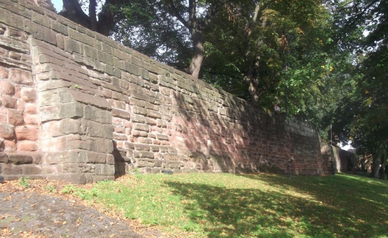
Part of east wall of Roman legionary fortress and of medieval
city. Late C1 to early C2 and late C11 to early C12, converted
to a raised promenade 1702-8 and repaired in various periods.
Purple-grey Roman ashlar masonry and softer red sandstone
rubble, medieval and later.
Roman masonry up to 4 courses high and 15m long forms the
projecting base to the wall north of Kaleyard Gate (qv).
Further south a portion of Roman masonry not closely
accessible when inspected rises to a maximum of 6 courses
standing a little proud of the medieval wall face.
The internal face of the wall immediately south of Kaleyard
Gate has a 5-metre run of continuous corbelling, formerly at
the base of the inner timber palisade to the rampart,
immediately below the wall-walk level. A ramp parallel with
the wall leads up from Abbey Street, stone-paved and with red
sandstone parapet with blocked opening of former doorway to
Cathedral Close. Along the Close the wall has panels of iron
rails between buttress-shaped piers.
Steps down leading to Frodsham Street at the site of a drum
tower of which the foundations are exposed, probably 1285-95.
Modern stone steps south of the Cathedral bell-tower lead down
to St Werburgh Street.
The portion of wall in this item is approx 370m long and from
2-3m wide. Archaeological excavation in 1991 revealed the
stone-faced outer ditch, to be built over.
(Strickland TJ: Roman Chester: Chester: 1984-1986: PASSIM;
Cheshire Sites and Monuments Record: Collens J: Chester City:
3000/1/18 & /2/10).
Listing NGR: SJ4066966492
External links are from the relevant listing authority and, where applicable, Wikidata. Wikidata IDs may be related buildings as well as this specific building. If you want to add or update a link, you will need to do so by editing the Wikidata entry.


Other nearby listed buildings
