Latitude: 51.5012 / 51°30'4"N
Longitude: -0.0674 / 0°4'2"W
OS Eastings: 534240
OS Northings: 179799
OS Grid: TQ342797
Mapcode National: GBR YJ.01
Mapcode Global: VHGR0.SJ7J
Plus Code: 9C3XGW2M+F3
Entry Name: East Lane Stairs
Listing Date: 1 July 1983
Last Amended: 17 September 1998
Grade: II
Source: Historic England
Source ID: 1376586
English Heritage Legacy ID: 470591
ID on this website: 101376586
Location: Wapping, Southwark, London, SE16
County: London
District: Southwark
Electoral Ward/Division: Riverside
Parish: Non Civil Parish
Built-Up Area: Southwark
Traditional County: Surrey
Lieutenancy Area (Ceremonial County): Greater London
Church of England Parish: Bermondsey St James with Christ Church
Church of England Diocese: Southwark
Tagged with: Architectural structure
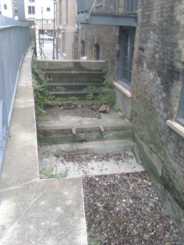
SOUTHWARK
TQ3479 BERMONDSEY WALL WEST
636-1/6/61 (North side)
01/07/83 East Lane Stairs
(Formerly Listed as:
RIVER STAIRS AND HARDS, Surrey Shore
East Lane Stairs and Hard)
II
River stairs appearing as such on Horwood's map of 1799 and
the OS of 1872; possibly the same as "East Stairs" on Roque's
map of 1746. Stone-flagged hard now broken up.
Listing NGR: TQ3424079799
External links are from the relevant listing authority and, where applicable, Wikidata. Wikidata IDs may be related buildings as well as this specific building. If you want to add or update a link, you will need to do so by editing the Wikidata entry.


Other nearby listed buildings