Approximate Location Map
Large Map »
Latitude: 51.5012 / 51°30'4"N
Longitude: -0.0675 / 0°4'3"W
OS Eastings: 534230
OS Northings: 179802
OS Grid: TQ342798
Mapcode National: GBR XJ.Z0
Mapcode Global: VHGR0.SJ5J
Plus Code: 9C3XGW2J+FX
Entry Name: 33, Bermondsey Wall West
Listing Date: 1 July 1983
Grade: II
Source: Historic England
Source ID: 1376585
English Heritage Legacy ID: 470589
ID on this website: 101376585
Location: Wapping, Southwark, London, SE16
County: London
District: Southwark
Electoral Ward/Division: Riverside
Parish: Non Civil Parish
Built-Up Area: Southwark
Traditional County: Surrey
Lieutenancy Area (Ceremonial County): Greater London
Church of England Parish: Bermondsey St James with Christ Church
Church of England Diocese: Southwark
Tagged with: Building
SOUTHWARK
TQ3479 BERMONDSEY WALL WEST
636-1/6/59 (North side)
01/07/83 No.33
GV II
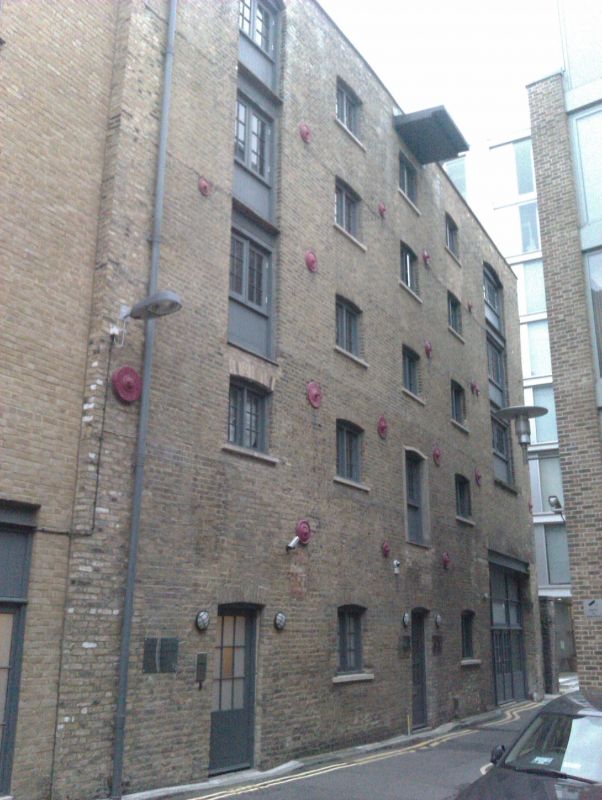
Granary, later London Grist Mills, 1866. Stock brick with
hipped slate roof with skylights, partly surmounted by timber
clerestory, possibly for housing a pneumatic grain intake,
seen from river behind plain parapet with coping.
PLAN: substantial rectangular building.
EXTERIOR: 5 storeys, 5 bays to street, 7 bays to river (2
blind) and 4 bays to east return. Street front slightly
convex, probably following the alignment of previous buildings
on site. Full height hatch ranks to street, river and east
elevations, that to river with hipped hood over the hoist.
Smallish 2-light wood mullioned windows with gauged brick
segmental arches on all floors. Circular tie-rod plates to
each elevation.
INTERIOR: internally construction is of timber with spreader
capped posts supporting the floors and open timber staircases.
A series of wooden chutes is said to remain in situ,
descending from the top floor to the 1st floor terminating in
a movable table system leading to a hand winch by the loading
hatch. The chutes are provided with a weighted box breaking
system.
HISTORICAL NOTE: became the London Grist Mills in 1891 and
remained as such up to 1940.
Prominent riverside site with its exposed east return
elevation. At time of survey, most windows broken or boarded
up.
Listing NGR: TQ3423079802
External links are from the relevant listing authority and, where applicable, Wikidata. Wikidata IDs may be related buildings as well as this specific building. If you want to add or update a link, you will need to do so by editing the Wikidata entry.


Other nearby listed buildings
