Latitude: 52.6502 / 52°39'0"N
Longitude: -2.4534 / 2°27'12"W
OS Eastings: 369423
OS Northings: 305926
OS Grid: SJ694059
Mapcode National: GBR BX.64QL
Mapcode Global: WH9D9.8NZ4
Plus Code: 9C4VMG2W+3J
Entry Name: Shropshire Canal aqueduct at SJ 69423 05931
Listing Date: 6 April 1993
Last Amended: 6 March 2025
Grade: II
Source: Historic England
Source ID: 1377111
English Heritage Legacy ID: 362529
ID on this website: 101377111
Location: Aqueduct, Telford and Wrekin, Shropshire, TF4
County: Telford and Wrekin
Civil Parish: Dawley Hamlets
Built-Up Area: Telford
Traditional County: Shropshire
Lieutenancy Area (Ceremonial County): Shropshire
Church of England Parish: Central Telford
Church of England Diocese: Lichfield
Tagged with: Aqueduct
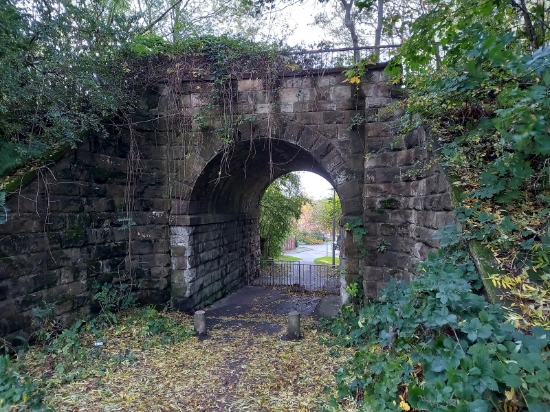
A stone aqueduct to carry the Shropshire Canal over the Wellington to Bridgnorth road, built around 1792.
A stone aqueduct to carry the Shropshire Canal over the Wellington to Madeley road, built around 1792.
MATERIALS: sandstone ashlar.
PLAN: trapezoid, orientated with the long parallel sides to the north-west and south-east, and the south-west end longer than the north-east.
EXTERIOR: the aqueduct is carried over the path below by an elliptical arch. The arch is formed by a single course of ashlar voussoir stones. The abutments are in ashlar blocks. Above the arch, ashlar blocks extend upwards and form parapets either side of the aqueduct, which is now infilled and carries a tarmac path rather than water in an iron trough. Iron railings are above the parapets, set back from the edge. A wall extends at right-angles to the north-west from the north elevation, retaining the soil of the steep road cutting to the north-east. The aqueduct has also been buttressed to its south side by a shorter wall in rubble stone projecting at right-angles to the south-west, this wall retains some of the slope of the road cutting to the south-west. Also on the south elevation is an oval metal plaque that bears the inscription: ‘BUILT c.1792 THIS / AQUEDUCT WAS RESTORED / IN 2001 / ALSO REMEMBERED HERE / ARE THE WAR DEAD OF / AQUEDUCT VILLAGE’.
The Shropshire Canal was authorised by an Act of Parliament of 1788, and funded by public subscription. The canal was constructed soon after authorisation, with the engineer being William Reynolds (1758-1803). The canal ran through what is now Telford, starting at Oakengates in the north, then running south to Southall, where it split into a western branch towards Coalbrookdale and an eastern branch to Coalport. The canal was used by small, unpowered tub boats, largely carrying coal and iron. From the mid-C19 parts of the Shropshire Canal were replaced by the railway, with the last canal section in use until 1912. The aqueduct is on the canal’s western branch (at National Grid reference SJ 69423 05931). It carried the canal over what was the old road from Wellington to Bridgnorth, but is now a lane running parallel with and between Mallory Drive and Southall Way, around 30m west of the Silkin Way cycle track. A plaque commemorating the war dead of the village was added to the aqueduct following restoration works carried out in 2001.
The Shropshire Canal aqueduct at SJ 69423 05931 is listed at Grade II for the following principal reasons:
Architectural interest:
* the design of the aqueduct shows engineering proficiency and successfully enabled the transportation of the canal over uneven terrain and the road.
Historic interest:
* the aqueduct illustrates the history of this late-C18 former inland waterway route and the industry it supported in an area central to England’s Industrial Revolution.
External links are from the relevant listing authority and, where applicable, Wikidata. Wikidata IDs may be related buildings as well as this specific building. If you want to add or update a link, you will need to do so by editing the Wikidata entry.


Other nearby listed buildings