Approximate Location Map
Large Map »
Latitude: 50.2257 / 50°13'32"N
Longitude: -5.2691 / 5°16'8"W
OS Eastings: 166926
OS Northings: 41307
OS Grid: SW669413
Mapcode National: GBR Z0.RYT5
Mapcode Global: VH12J.ML99
Plus Code: 9C2P6PGJ+79
Entry Name: Former Miners Dry, Bickfords and Palmers Shafts, South Crofty Mine
Listing Date: 27 October 1999
Grade: II
Source: Historic England
Source ID: 1379216
English Heritage Legacy ID: 478584
ID on this website: 101379216
Location: Pool, Cornwall, TR15
County: Cornwall
Civil Parish: Carn Brea
Built-Up Area: Camborne
Traditional County: Cornwall
Lieutenancy Area (Ceremonial County): Cornwall
Church of England Parish: Saint Illogan
Church of England Diocese: Truro
Tagged with: Architectural structure
SW 64 SE CARN BREA STATION ROAD
(West side)
501/5/10016
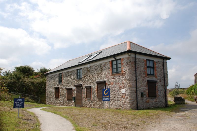
Former Miners' Dry, Bickford's
And Palmer's Shafts, South
Crofty Mine
GV II
Miner's dry, later cooperage, now disused. 1863. Killas rubble with granite dressings and slate roof. Two storey; 3-window range, window frames removed or blocked, with iron steps up to left-hand end, and a small porch added to centre; right-hand end with 6/6 sashes.
INTERIOR: reported to have softwood trusses.
HISTORY: In 1863, South Wheal Crofty was reorganised from the old workings of East Wheal Crofty by the manager, Capt. William Rutter, placing the surviving ancillary buildings in a semi-square to the N of the two shafts, Bickford's and Palmer's. New survey rooms were later added, and the miner's dry used as a cooperage, stores, and training school. A rare surviving example of a type of building which characterised the mine groups of the Cornish orefields, the date of its construction representing the apogee of Cornish mining before the advent of compressors and rock drills and the severe contraction of the industry from the 1870s.
(Buckley, J A; Robinson's Engine House and Environs: an Assessment, (Report for Cornwall Country Council), 1990)
Listing NGR: SW6692641307
External links are from the relevant listing authority and, where applicable, Wikidata. Wikidata IDs may be related buildings as well as this specific building. If you want to add or update a link, you will need to do so by editing the Wikidata entry.


Other nearby listed buildings
