Latitude: 50.3315 / 50°19'53"N
Longitude: -4.7572 / 4°45'26"W
OS Eastings: 203863
OS Northings: 51588
OS Grid: SX038515
Mapcode National: GBR N1.XFTV
Mapcode Global: FRA 08X5.4H5
Plus Code: 9C2Q86JV+J4
Entry Name: Former Warehouse and Net Loft
Listing Date: 8 November 1999
Grade: II
Source: Historic England
Source ID: 1379459
English Heritage Legacy ID: 478845
ID on this website: 101379459
Location: Charlestown, Cornwall, PL25
County: Cornwall
Civil Parish: St Austell Bay
Built-Up Area: St Austell
Traditional County: Cornwall
Lieutenancy Area (Ceremonial County): Cornwall
Church of England Parish: Charlestown
Church of England Diocese: Truro
Tagged with: Former warehouse
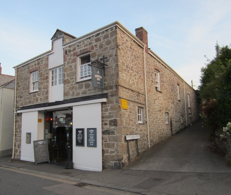
SX 0351 NE ST AUSTELL CHARLESTOWN ROAD, Charlestown
(West side)
868-0/4/10040
Former Warehouse and Net Loft
GV II
Probable stables for public house, later used as boat house and net loft. Early C19 (shown on 1843 tithe map). Killas and granite rubble with granite dressings; dry Delabole slate roof, hipped at the front, stepped down to narrower building behind front range and returned at rear left to a gable end. Deep L-shaped plan, built into a slope at the rear. EXTERIOR: 2 storeys; 2-window front range with central 1st-floor loading doorway with loft doorway over, flanked by segmental brick arches over horned late C19 6/6-pane sashes. Ground floor has wide central doorway with sliding boarded doors. The side elevations have regularly spaced window and door openings spanned by timber lintels and segmental brick arches. There are 2 1st-floor loading doorways. Most windows are late C19 12-pane horned sashes and the doorways have planked doors. INTERIOR not inspected except to note that heavy cross beams of original floor structure have been removed. The roof structure is likely to be original. Part of an important and little altered group in this former fishing and china clay port.
Listing NGR: SX0386351588
External links are from the relevant listing authority and, where applicable, Wikidata. Wikidata IDs may be related buildings as well as this specific building. If you want to add or update a link, you will need to do so by editing the Wikidata entry.


Other nearby listed buildings