Approximate Location Map
Large Map »
Latitude: 50.3317 / 50°19'54"N
Longitude: -4.7573 / 4°45'26"W
OS Eastings: 203858
OS Northings: 51607
OS Grid: SX038516
Mapcode National: GBR N1.XFTS
Mapcode Global: FRA 08X5.4FZ
Plus Code: 9C2Q86JV+M3
Entry Name: 21, Charlestown Road
Listing Date: 11 March 1974
Grade: II
Source: Historic England
Source ID: 1218829
English Heritage Legacy ID: 70675
ID on this website: 101218829
Location: Charlestown, Cornwall, PL25
County: Cornwall
Civil Parish: St Austell Bay
Built-Up Area: St Austell
Traditional County: Cornwall
Lieutenancy Area (Ceremonial County): Cornwall
Church of England Parish: Charlestown
Church of England Diocese: Truro
Tagged with: Building
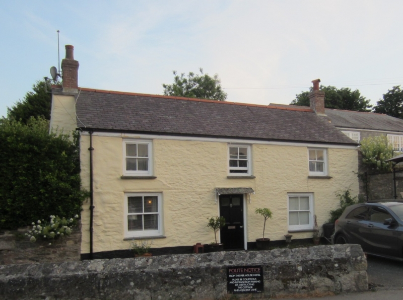
CHARLESTOWN
1. CHARLESTOWN ROAD
1584A (West Side)
No 21
SX 0351 NE 4/14
II GV
2.
C18 cottage of colourwashed rubble. Low 2 storeys. 3 windows, small
sashes without glazing bars. Central door, panelled. Slate roof with
gable ends. Outbuilt chimney at each end. Included for group value.
No 15, Warehouse north of No 15 and No 21 form a group.
Listing NGR: SX0385851607
External links are from the relevant listing authority and, where applicable, Wikidata. Wikidata IDs may be related buildings as well as this specific building. If you want to add or update a link, you will need to do so by editing the Wikidata entry.


Other nearby listed buildings
