Latitude: 53.5677 / 53°34'3"N
Longitude: -0.0708 / 0°4'15"W
OS Eastings: 527855
OS Northings: 409633
OS Grid: TA278096
Mapcode National: GBR WWY5.GS
Mapcode Global: WHHHS.WLF8
Plus Code: 9C5XHW9H+3M
Entry Name: St Marys Presbytery
Listing Date: 30 June 1999
Grade: II
Source: Historic England
Source ID: 1379850
English Heritage Legacy ID: 479284
ID on this website: 101379850
Location: East Marsh, North East Lincolnshire, DN32
County: North East Lincolnshire
Electoral Ward/Division: East Marsh
Parish: Non Civil Parish
Built-Up Area: Grimsby
Traditional County: Lincolnshire
Lieutenancy Area (Ceremonial County): Lincolnshire
Church of England Parish: Great Grimsby St Andrew with St Luke and All Saints
Church of England Diocese: Lincoln
Tagged with: Architectural structure
GRIMSBY
TA2709NE HENEAGE ROAD
699-1/18/38 (East side)
St Mary's Presbytery
GV II
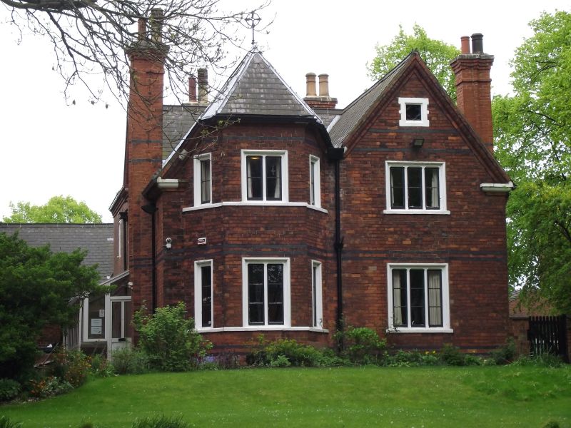
Presbytery. c1880, probably by Hadfield and Son of Sheffield,
architects of the adjoining St Mary's church (qv); early C20
addition to rear. Red brick in stretcher bond with black brick
and painted stone dressings. Welsh slate roof. Original range
rectangular on plan, with later wing to rear adjoining St
Mary's church.
EXTERIOR: balanced asymmetrical design. 2 storeys with attic,
irregular fenestration. Plinth with 2 black brick bands above.
Entrance front to south has door and windows in a continuous
quoined ashlar surround with chamfered reveals with label
stops. Board door with rounded brackets to lintel and
mullioned overlight with 2 quatrefoiled lights. Single-light
window to left, and 3 similar lights to right, all with single
transoms, quatrefoiled top lights, and leaded panes. 2 black
brick bands at lintel level. Recessed carved stone panel above
entrance with "SM" cypher on a shield below bishop's mitre.
3-light first-floor mullioned window in moulded reveal; narrow
single-light window to right. Above this, a gable with brick
bands and a small quatrefoiled attic window in a quoined
surround. To the left, an elaborate projecting stack with a
carved bishop's head corbel at ground-floor level, ribbed
chimney-shafts and corbelled brick cap. Ovolo-moulded brick
eaves cornice. Hipped and gabled roof with ornate wrought-iron
finials.
Left return forms front to Heneage Road: twin-gabled, the
section to the right with a 3-light window to each floor and a
quatrefoiled attic window, the section to the left with a
full-height canted brick bay with 2-light and single-light
windows, sill bands and hipped roof. North front facing church
has lateral stack similar to south front but with a different
head corbel; C20 replacement glazing to enclosed entrance
passage. 2-storey rear addition has leaded casements,
corbelled eaves, hipped roof, lateral stack with diagonal
shafts.
INTERIOR: not inspected.
Along with the associated garden walls and St Mary's Church
(qv), forms part of a notable group of Victorian and Edwardian
educational and religious buildings built on land provided by
the Heneage Estate.
Listing NGR: TA2785509633
External links are from the relevant listing authority and, where applicable, Wikidata. Wikidata IDs may be related buildings as well as this specific building. If you want to add or update a link, you will need to do so by editing the Wikidata entry.


Other nearby listed buildings