Approximate Location Map
Large Map »
Latitude: 51.1282 / 51°7'41"N
Longitude: -0.9901 / 0°59'24"W
OS Eastings: 470763
OS Northings: 137031
OS Grid: SU707370
Mapcode National: GBR B8C.8HC
Mapcode Global: VHDYB.SXF0
Plus Code: 9C3X42H5+7W
Entry Name: Churchyard Wall West of Church of St Nicholas
Listing Date: 9 May 2000
Grade: II
Source: Historic England
Source ID: 1380313
English Heritage Legacy ID: 480297
ID on this website: 101380313
Location: Chawton, East Hampshire, GU34
County: Hampshire
District: East Hampshire
Civil Parish: Chawton
Traditional County: Hampshire
Lieutenancy Area (Ceremonial County): Hampshire
Church of England Parish: Chawton St Nicholas
Church of England Diocese: Winchester
Tagged with: Churchyard wall
SU73NW
559/2/10011
09-MAY-00
CHAWTON
FORMER A32
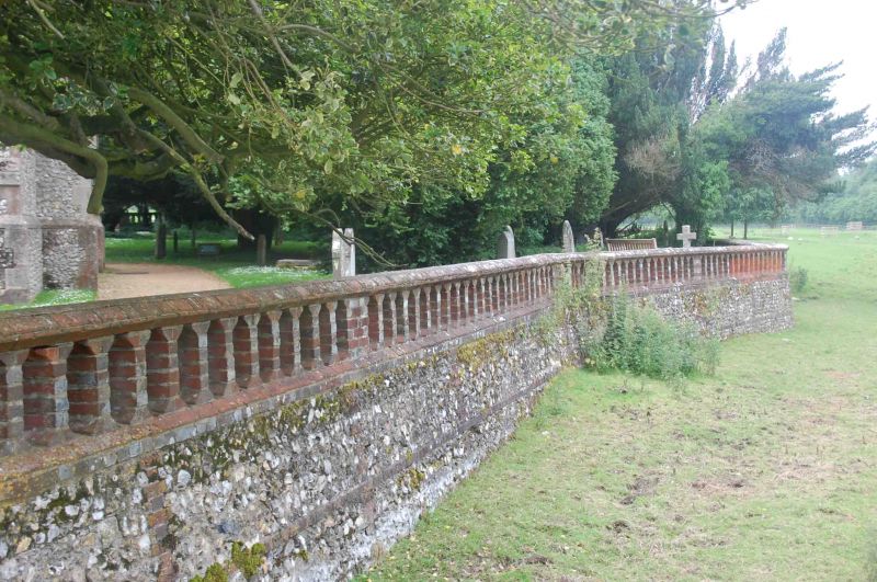
Churchyard wall west of Church of St Nicholas
GV
II
Churchyard boundary wall. Circa 1871; probably by Sir Arthur Blomfield. Flint with red brick dressings. Battered flint revetment to raised churchyard with brick string and brick parapet pierced with arched openings.
External links are from the relevant listing authority and, where applicable, Wikidata. Wikidata IDs may be related buildings as well as this specific building. If you want to add or update a link, you will need to do so by editing the Wikidata entry.


Other nearby listed buildings
