Approximate Location Map
Large Map »
Latitude: 50.8218 / 50°49'18"N
Longitude: -0.1372 / 0°8'13"W
OS Eastings: 531309
OS Northings: 104124
OS Grid: TQ313041
Mapcode National: GBR JP4.G4F
Mapcode Global: FRA B6LX.QCL
Plus Code: 9C2XRVC7+P4
Entry Name: Three bus shelters
Listing Date: 21 October 1993
Grade: II
Source: Historic England
Source ID: 1380714
English Heritage Legacy ID: 481038
ID on this website: 101380714
Location: Brighton, Brighton and Hove, West Sussex, BN1
County: The City of Brighton and Hove
Electoral Ward/Division: St. Peter's and North Laine
Parish: Non Civil Parish
Built-Up Area: Brighton and Hove
Traditional County: Sussex
Lieutenancy Area (Ceremonial County): East Sussex
Church of England Parish: Brighton The Chapel
Church of England Diocese: Chichester
Tagged with: Architectural structure
This list entry was subject to a Minor Amendment on 14/03/2019
TQ3104SW
577-1/40/665
BRIGHTON
OLD STEINE
Three bus shelters
(Formerly listed as Three tram shelters, PAVILION PARADE (west side))
21/10/93
II
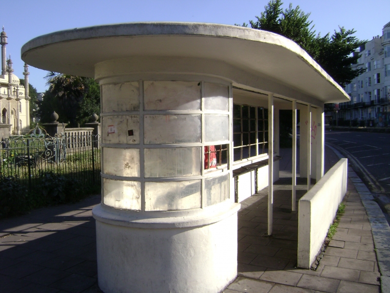
Three bus shelters, of around 1950, probably designed to match the former tram shelter and public toilets to the south, which were designed by the Borough Engineer, David Edwards, (List entry 1380683). The bus shelters have reinforced concrete walls, with metal columns and glazing bars. Each narrow, single-storey structure is rectangular in plan with apsidal ends. The side to road is open for access to buses, and the walls are glazed on the pavement side. The centre shelter is of three bays, and the outer pair of four. All are in the International Style. The back walls of all are formed by a low parapet topped by glass wall set in steel glazing bars. The glass wall is carried around south end, and the north end is pierced by a flat-arched entrance, which is blocked in the southernmost shelter. Along the side open to the road, there is a plain lintel supported by thin metal columns which also function as downspouts. The flat roof projects out over the walls below and follows the overall lozenge-shaped plan.
Listing NGR: TQ3130904124
External links are from the relevant listing authority and, where applicable, Wikidata. Wikidata IDs may be related buildings as well as this specific building. If you want to add or update a link, you will need to do so by editing the Wikidata entry.


Other nearby listed buildings
