Latitude: 50.8074 / 50°48'26"N
Longitude: -0.0589 / 0°3'31"W
OS Eastings: 536866
OS Northings: 102665
OS Grid: TQ368026
Mapcode National: GBR KQR.9Y3
Mapcode Global: FRA B6RY.YNW
Plus Code: 9C2XRW4R+XF
Entry Name: Walls to Kipling Gardens and Related Buildings
Listing Date: 13 October 1952
Last Amended: 26 August 1999
Grade: II
Source: Historic England
Source ID: 1381022
English Heritage Legacy ID: 481365
ID on this website: 101381022
Location: Kipling Gardens, Rottingdean, Brighton and Hove, West Sussex, BN2
County: The City of Brighton and Hove
Civil Parish: Rottingdean
Built-Up Area: Saltdean
Traditional County: Sussex
Lieutenancy Area (Ceremonial County): East Sussex
Church of England Parish: Rottingdean St Margaret
Church of England Diocese: Chichester
Tagged with: Wall
BRIGHTON
TQ3602NE THE GREEN, Rottingdean
577-1/60/1089 Walls to Kipling Gardens and related
13/10/52 buildings
(Formerly Listed as:
THE GREEN, Rottingdean
Garden wall of The Elms)
GV II
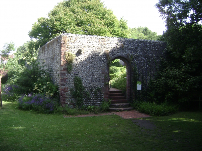
Garden walls. Probably of C18 and C19 date. Flint and cobbles
with red brick dressings. Approx 70 metres on the south side
as far as the public shelter, including a plaque recording the
fact that Rudyard Kipling lived at The Elms (qv) between 1897
and 1903; the shelter is a former outbuilding of The Elms, of
flint with brick dressings, roof of tiles, bracketed awning to
south, open on the north and east sides, gabled dormers,
hipped roof; approx 10 further metres to the south-west
corner. On the west side, approx 75 metres, including some
brickwork perhaps relating to cottages formerly on the site;
on the north side, approx 80 metres including 2 sets of gates;
on the east side, approx 80 metres as far as the renovated
garage building to The Elms, and a further stretch of approx
20 metres.
Within the gardens there are 3 additional ranges of walls; one
approx 25 metres east of the west wall, approx 80 metres in
length; another approx 15 metres east of that, approx 75
metres in length; and a third, running east-west, approx 8
metres south of the north wall, approx 60 metres in length;
there are also a pergola with flint columns at the centre of
the gardens, and at their north-west corner, 2 lean-to sheds
of flint with brick dressings and flat-arched windows, one
slightly higher than the other; these are said to have been
outhouses in connection with cottages at the north-west corner
of the Gardens. Among the walls there are generally openings,
some of them rebated for doors or gates.
The former listing, which applied to the boundary walls of the
garden of The Elms (qv), has been extended here to include all
the walls incorporated in Kipling Gardens when it became a
public garden in 1983.
(Carder T: The Encyclopaedia of Brighton: Lewes: 1990-).
Listing NGR: TQ3686602665
External links are from the relevant listing authority and, where applicable, Wikidata. Wikidata IDs may be related buildings as well as this specific building. If you want to add or update a link, you will need to do so by editing the Wikidata entry.


Other nearby listed buildings