Approximate Location Map
Large Map »
Latitude: 52.1707 / 52°10'14"N
Longitude: -1.5464 / 1°32'47"W
OS Eastings: 431115
OS Northings: 252592
OS Grid: SP311525
Mapcode National: GBR 5NJ.ZT3
Mapcode Global: VHBY3.4PTS
Plus Code: 9C4W5FC3+7C
Entry Name: Bridge Carrying B4086 over Compton Pool
Listing Date: 5 April 1967
Last Amended: 19 August 1999
Grade: II
Source: Historic England
Source ID: 1381872
English Heritage Legacy ID: 482237
ID on this website: 101381872
Location: Combrook, Stratford-on-Avon, Warwickshire, CV35
County: Warwickshire
District: Stratford-on-Avon
Civil Parish: Combrook
Traditional County: Warwickshire
Lieutenancy Area (Ceremonial County): Warwickshire
Church of England Parish: Combroke St Mary and St Margaret
Church of England Diocese: Coventry
Tagged with: Bridge
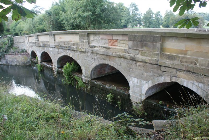
COMPTON VERNEY
SP35SW B 4086, Compton Verney
1901-1/6/64 Bridge carrying B 4086 over Compton
05/04/67 Pool
(Formerly Listed as:
COMPTON VERNEY
Bridge carrying public road over
Compton Pool)
GV II
Bridge. 1770s. Probably by Lancelot 'Capability' Brown (or
Robert Adam). Limestone ashlar. 5 elliptical-headed arches,
with widest arch to centre and stone parapet. Built as part of
`Capability' Brown's landscaping of Compton Verney Park
1768-74.
(Shell Guides: Hickman D: Warwickshire: London: 1979-: 81).
Listing NGR: SP3111552592
External links are from the relevant listing authority and, where applicable, Wikidata. Wikidata IDs may be related buildings as well as this specific building. If you want to add or update a link, you will need to do so by editing the Wikidata entry.


Other nearby listed buildings
