Approximate Location Map
Large Map »
Latitude: 52.2734 / 52°16'24"N
Longitude: -1.7582 / 1°45'29"W
OS Eastings: 416595
OS Northings: 263940
OS Grid: SP165639
Mapcode National: GBR 4KS.DB6
Mapcode Global: VHB04.G4W2
Plus Code: 9C4W76FR+8P
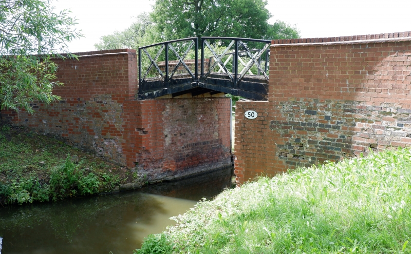
Entry Name: Canal Bridge Number 50 (Preston Hill Farm Bridge)
Listing Date: 4 January 1990
Grade: II
Source: Historic England
Source ID: 1382162
English Heritage Legacy ID: 482528
ID on this website: 101382162
Location: Stratford-on-Avon, Warwickshire, B95
County: Warwickshire
District: Stratford-on-Avon
Civil Parish: Preston Bagot
Traditional County: Warwickshire
Lieutenancy Area (Ceremonial County): Warwickshire
Church of England Parish: Preston Bagot All Saints
Church of England Diocese: Coventry
Tagged with: Bridge
SP16SE
1457-1/5/97
04/01/90
PRESTON BAGOT
SOUTH STRATFORD CANAL
Canal Bridge No.50
II
Also known as: Preston Hill Farm Bridge SOUTH STRATFORD CANAL.
Split bridge. c1812-1816, restored 1980s. Brick abutments and
walls, with cast-iron rails and decks. Abutments support 2
cantilevered decks with integral x-framed handrails and are
split for tow ropes. Splayed parapet walls with brick copings,
rebuilt 1980s.
The South Stratford Canal was constructed between 1793-1816 at
a cost of £500,000. 13.5 miles of the canal from Kingswood
Junction, Lapworth to Stratford-upon-Avon was leased by the
National Trust in 1960 from the British Waterways Board for
restoration. The National Trust acquired the freehold c1964.
Listing NGR: SP1659563940
External links are from the relevant listing authority and, where applicable, Wikidata. Wikidata IDs may be related buildings as well as this specific building. If you want to add or update a link, you will need to do so by editing the Wikidata entry.


Other nearby listed buildings
