Latitude: 51.2101 / 51°12'36"N
Longitude: -2.6482 / 2°38'53"W
OS Eastings: 354815
OS Northings: 145850
OS Grid: ST548458
Mapcode National: GBR MN.42WL
Mapcode Global: VH89S.1VV7
Plus Code: 9C3V6962+2P
Entry Name: 18, Chamberlain Street
Listing Date: 13 September 1972
Grade: II
Source: Historic England
Source ID: 1382927
English Heritage Legacy ID: 483330
ID on this website: 101382927
Location: Wells, Somerset, BA5
County: Somerset
District: Mendip
Civil Parish: Wells
Built-Up Area: Wells
Traditional County: Somerset
Lieutenancy Area (Ceremonial County): Somerset
Tagged with: Building
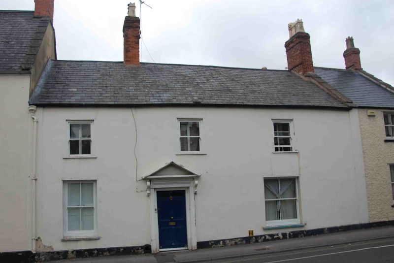
WELLS
ST5445 CHAMBERLAIN STREET
662-1/7/57 (North side)
13/09/72 No.18
GV II
House in row. Early C19, probably a refronting of C18 or
earlier house. Rendered with false ashlar jointing,
colourwash, Welsh slate roof between abutments, brick chimney
stack.
EXTERIOR: 2 storeys, 3 bays. Plinth, Plain end pilasters.
Plain sash windows in plain openings, the lower windows
subdivided into 4 panes, central bay has a 6-panel door in
timber surround with reeded architrave and pediment hood on
console brackets, with a footscraper to the left.
INTERIOR: not inspected.
Fenestration layout to facade indicates that No.18 originated
as a 2-unit house with an unheated service room to left of
entrance and large heated room to right.
Listing NGR: ST5481545850
External links are from the relevant listing authority and, where applicable, Wikidata. Wikidata IDs may be related buildings as well as this specific building. If you want to add or update a link, you will need to do so by editing the Wikidata entry.


Other nearby listed buildings