Latitude: 51.2103 / 51°12'37"N
Longitude: -2.6468 / 2°38'48"W
OS Eastings: 354914
OS Northings: 145875
OS Grid: ST549458
Mapcode National: GBR MN.437S
Mapcode Global: VH89S.2VL2
Plus Code: 9C3V6963+47
Entry Name: 29, Sadler Street
Listing Date: 13 September 1972
Grade: II
Source: Historic England
Source ID: 1383099
English Heritage Legacy ID: 483517
ID on this website: 101383099
Location: Wells, Somerset, BA5
County: Somerset
District: Mendip
Civil Parish: Wells
Built-Up Area: Wells
Traditional County: Somerset
Lieutenancy Area (Ceremonial County): Somerset
Tagged with: Building
WELLS
ST5445 SADLER STREET
662-1/7/235 (West side)
13/09/72 No.29
GV II
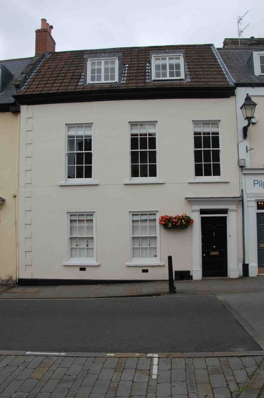
House. Later C18. Rendered with stone dressings, colourwashed,
triple roll clay tiled roof with stepped coped gable to south,
abutment to north, brick chimney stacks.
EXTERIOR: 2 storeys with attic, 3 bays. Plinth, keyed quoin to
south, eaves moulding. Sash windows of 12 panes, the
first-floor windows larger. Doorway in bay 3, with 6-panel
door and narrow rectangular fanlight set in stone surround
having plain Doric pilasters and entablature with flat hood,
footscraper to left. In roof, two flat-roofed dormers with
2-light 6-pane casements, centred between bays.
INTERIOR: not inspected.
Listing NGR: ST5491445875
External links are from the relevant listing authority and, where applicable, Wikidata. Wikidata IDs may be related buildings as well as this specific building. If you want to add or update a link, you will need to do so by editing the Wikidata entry.


Other nearby listed buildings