Approximate Location Map
Large Map »
Latitude: 51.2081 / 51°12'29"N
Longitude: -2.6506 / 2°39'1"W
OS Eastings: 354650
OS Northings: 145633
OS Grid: ST546456
Mapcode National: GBR MN.429N
Mapcode Global: VH89S.0WMR
Plus Code: 9C3V685X+6Q
Entry Name: Walls Enclosing Churchyard of St Cuthbert
Listing Date: 31 May 2000
Grade: II
Source: Historic England
Source ID: 1383113
English Heritage Legacy ID: 483531
ID on this website: 101383113
Location: St Cuthbert's Church, Wells, Somerset, BA5
County: Somerset
District: Mendip
Town: Mendip
Civil Parish: Wells
Built-Up Area: Wells
Traditional County: Somerset
Lieutenancy Area (Ceremonial County): Somerset
Tagged with: Wall
WELLS
ST5445 ST CUTHBERT STREET
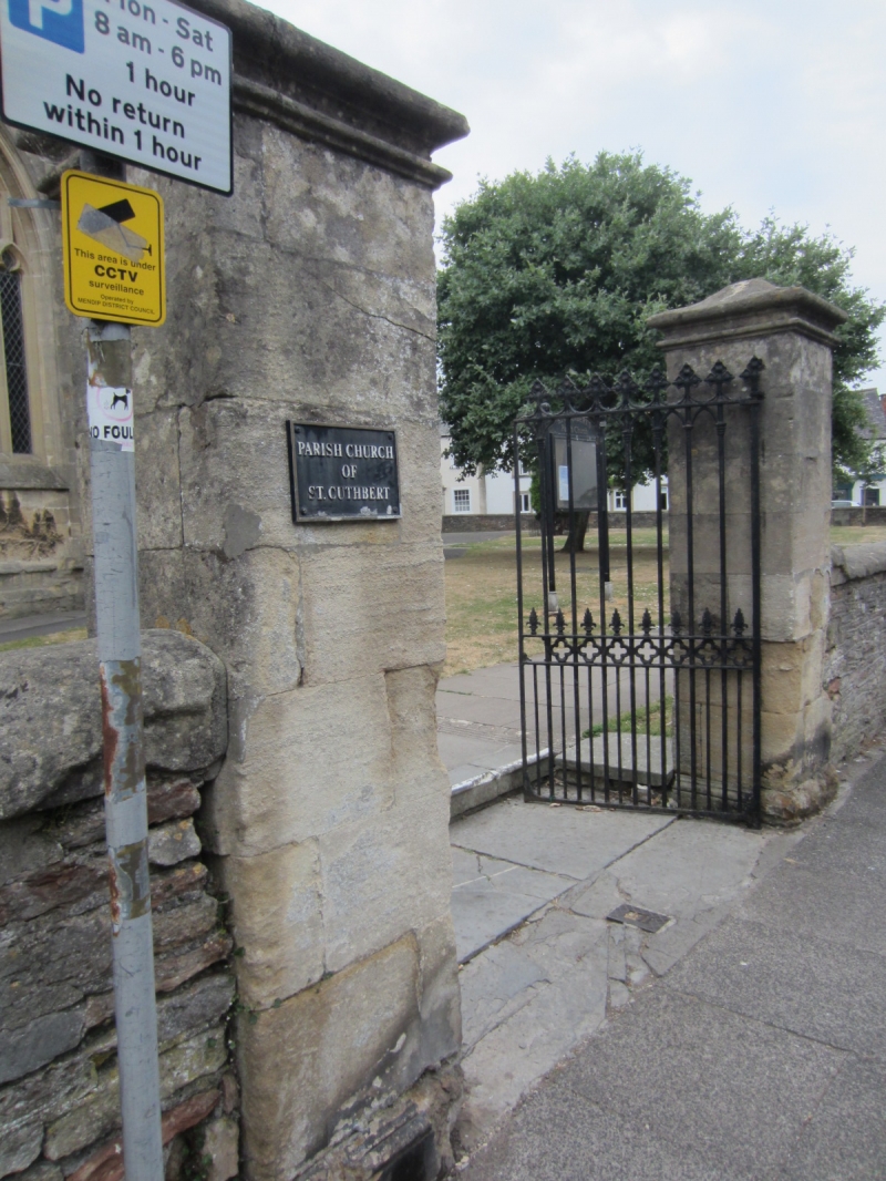
662-1/7/252 (North side)
Walls enclosing churchyard of St
Cuthbert
GV II
Churchyard boundary walling. Various dates, but most
apparently early C19. Random rubble local stone, with ashlar
copings and gate piers. On north side, against the The Old
Almshouse, Chamberlain Street (qv), average 1m high, with
pitched coping, gate in north-east corner having square ashlar
gate piers with plinths, moulded shallow bell-hip tops, and
cast-iron gateposts and gates with spear rails and curved
braces.
East wall has flatter rounded coping, averaging 1m high,
curving inwards towards south-east corner, with opening on
corner with plain rectangular piers to same height as wall.
Return along south side to match, with gateway opposite south
porch and piers matching north-east corner but taller, with a
pair of cast-iron gates having ornamental cross finials and
other decorations.
The west wall forms the boundary with sundry adjoining
properties, and breaks westward about mid length-at this point
a stone lean-to building of C19 date, possibly a former
mortuary chapel, this wall averages 2.5m height.
Further north wall, about 2.5m height, with gateway in centre,
along boundary with Chamberlain Street back to the Almshouses.
Listing NGR: ST5465145633
External links are from the relevant listing authority and, where applicable, Wikidata. Wikidata IDs may be related buildings as well as this specific building. If you want to add or update a link, you will need to do so by editing the Wikidata entry.


Other nearby listed buildings
