Latitude: 54.2793 / 54°16'45"N
Longitude: -2.4507 / 2°27'2"W
OS Eastings: 370754
OS Northings: 487164
OS Grid: SD707871
Mapcode National: GBR CLBY.7R
Mapcode Global: WH94C.BP8S
Plus Code: 9C6V7GHX+PP
Entry Name: Church Bridge
Listing Date: 14 June 1984
Grade: II
Source: Historic England
Source ID: 1383805
English Heritage Legacy ID: 484237
ID on this website: 101383805
Location: Dent, Westmorland and Furness, Cumbria, LA10
County: Cumbria
District: South Lakeland
Civil Parish: Dent
Traditional County: Yorkshire
Lieutenancy Area (Ceremonial County): Cumbria
Church of England Parish: Dent with Cowgill
Church of England Diocese: Carlisle
Tagged with: Bridge
DENT
SD7087 CHURCH BRIDGE, Dent Town
162-1/24/179 Church Bridge
14/06/84
II
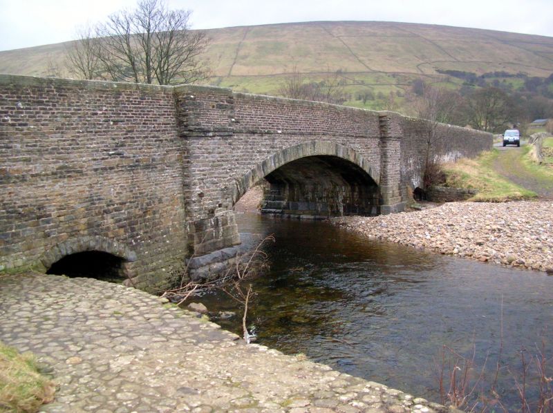
Public road bridge over River Dee. Probably late C18. Coursed
sandstone rubble with hammer-dressed plinths and voussoirs,
chiselled coping to parapets. Wide segmental arch with dressed
voussoirs, springing from broad terminal piers with stepped
plinths; string course to parapets. Long ramp abutments to
east and west, that to the west with a low stilted
segmental-arched flood sluice under it.
Listing NGR: SD7075487164
External links are from the relevant listing authority and, where applicable, Wikidata. Wikidata IDs may be related buildings as well as this specific building. If you want to add or update a link, you will need to do so by editing the Wikidata entry.


Other nearby listed buildings