Approximate Location Map
Large Map »
Latitude: 54.3403 / 54°20'24"N
Longitude: -2.3595 / 2°21'34"W
OS Eastings: 376723
OS Northings: 493917
OS Grid: SD767939
Mapcode National: GBR CLY7.ZW
Mapcode Global: WH946.Q5MH
Plus Code: 9C6V8JRR+45
Entry Name: East Scale Farmhouse with Outbuilding Attached to West
Listing Date: 18 October 1999
Grade: II
Source: Historic England
Source ID: 1384002
English Heritage Legacy ID: 484434
ID on this website: 101384002
Location: Westmorland and Furness, Cumbria, LA10
County: Cumbria
District: South Lakeland
Civil Parish: Garsdale
Traditional County: Yorkshire
Lieutenancy Area (Ceremonial County): Cumbria
Church of England Parish: Sedbergh, Cautley and Garsdale
Church of England Diocese: Carlisle
Tagged with: Farmhouse
GARSDALE
SD79SE GRISDALE
162-1/8/209 East Scale Farmhouse with
outbuilding attached to west
GV II
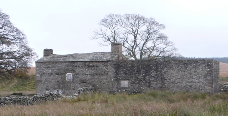
Farmhouse and associated outbuildings, now derelict and large
outbuilding at west end now a roofless shell. Probably C17 or
earlier, raised and remodelled in mid C18; large outbuilding
added between these phases. Watershot coursed sandstone rubble
with quoins to east end, 2 intermittent courses of
through-stones at 1st floor, stone slate roof. Single-depth
2-unit plan on east-west axis facing south, with large
outbuilding at west end, lean-to cart-shed added at east end.
EXTERIOR: 2 storeys and 3 windows, symmetrical; with a plinth
and a stone slate drip-course over the ground floor; a
square-headed doorway in the centre, with a board door, 2
square windows at ground floor with monolith lintels (that to
left lacking joinery and that to right lacking glazing), and 3
small rectangular sashes above (all with damaged joinery and
lacking glazing). Gable chimneys, both corbelled. The west
gable wall has a very steep gable line of the original
single-storey house. Roofless outbuilding at this end (perhaps
formerly a house) of equivalent size and height, with 2 widely
separated windows, has a doorway in the centre and 2
rectangular windows on each floor, those above slightly
smaller, all these openings with monolith lintels and all now
void. Rear: house has through-stones on 3 levels, small
chamfered 1-light window to left at ground floor and similar
stair-window in centre; L-shaped vertical joint with quoining
to outbuilding (suggesting that it was built before the house
was raised).
INTERIOR (seen through window): lateral stone partition wall
to right of doorway, board partition to left; housepart to
left has chamfered beam, exposed joists and fireplace with
corbelled lintel.
Forms group with West Scale (qv) approx. 100m north, and with
bridge over Grisdale Beck (qv) approx. 50m east.
Listing NGR: SD7672393917
External links are from the relevant listing authority and, where applicable, Wikidata. Wikidata IDs may be related buildings as well as this specific building. If you want to add or update a link, you will need to do so by editing the Wikidata entry.


Other nearby listed buildings
