Approximate Location Map
Large Map »
Latitude: 54.3264 / 54°19'35"N
Longitude: -2.5204 / 2°31'13"W
OS Eastings: 366249
OS Northings: 492442
OS Grid: SD662924
Mapcode National: GBR BLVD.4V
Mapcode Global: WH944.8J14
Plus Code: 9C6V8FGH+HR
Entry Name: Barn Approximately 15 Metres South East of Castlehaw Farmhouse
Listing Date: 16 March 1954
Last Amended: 18 October 1999
Grade: II
Source: Historic England
Source ID: 1384086
English Heritage Legacy ID: 484518
ID on this website: 101384086
Location: Sedbergh, Westmorland and Furness, Cumbria, LA10
County: Cumbria
District: South Lakeland
Civil Parish: Sedbergh
Built-Up Area: Sedbergh
Traditional County: Yorkshire
Lieutenancy Area (Ceremonial County): Cumbria
Church of England Parish: Sedbergh, Cautley and Garsdale
Church of England Diocese: Carlisle
Tagged with: Barn
SEDBERGH
SD6692 CASTLEHAW LANE
162-1/17/277 (East side)
16/03/54 Barn approx. 15 metres south-east of
Castlehaw Farmhouse
(Formerly Listed as:
CASTLEHAW LANE
Castlehaw Farmhouse and barns to
south-east)
GV II
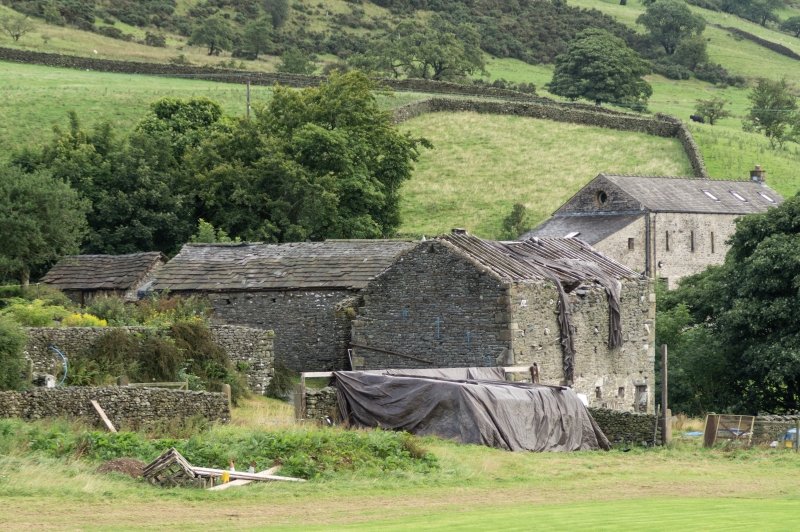
Barn and shippon. Probably early to mid C18; altered. Mixed
random rubble with quoins, roof with green slate upper and
stone slate lower courses, both graduated. L-plan formed by
main range on north-south axis with storeyed shippon-wing at
south end projecting to west.
EXTERIOR: the main range has a wagon doorway in the angle with
the wing, with a re-used timber lintel and C19 harr-hung
doors, protected by a porch with rubble side-wall and
monopitched roof; left of the porch is an interrupted course
of through-stones close to the eaves and carried along about
half the length, and 3 crudely-shaped breathers; further left
is a doorway with a monolith lintel, and left of this a
cart-shed doorway with a timber lintel protected by a slate
course. The south front of the wing, on lower ground, has a
ground-floor shippon which has 2 doorways and 3 windows
(w-d-w-w-d), all with stone lintels; small square breathers on
3 levels above, and some random through-stones.
INTERIOR: main range has stone partition walls to the 2 north
bays, but the remainder forms a single vessel with the upper
floor of the wing, both parts having principal-rafter roof
trusses (including some re-used timbers). Forms a group with
Castlehaw Farmhouse to the north-west (qv).
Listing NGR: SD6624992442
External links are from the relevant listing authority and, where applicable, Wikidata. Wikidata IDs may be related buildings as well as this specific building. If you want to add or update a link, you will need to do so by editing the Wikidata entry.


Other nearby listed buildings
