Approximate Location Map
Large Map »
Latitude: 52.3272 / 52°19'37"N
Longitude: 1.6814 / 1°40'52"E
OS Eastings: 650942
OS Northings: 276284
OS Grid: TM509762
Mapcode National: GBR YX3.5WT
Mapcode Global: VHM76.3R7T
Plus Code: 9F438MGJ+VH
Entry Name: The Lighthouse
Listing Date: 22 November 1971
Last Amended: 30 March 2000
Grade: II
Source: Historic England
Source ID: 1384444
English Heritage Legacy ID: 484878
Also known as: Southwold Lighthouse
ID on this website: 101384444
Location: Southwold, East Suffolk, IP18
County: Suffolk
District: East Suffolk
Civil Parish: Southwold
Built-Up Area: Southwold
Traditional County: Suffolk
Lieutenancy Area (Ceremonial County): Suffolk
Church of England Parish: Southwold St Edmund, King and Martyr
Church of England Diocese: St.Edmundsbury and Ipswich
Tagged with: Lighthouse
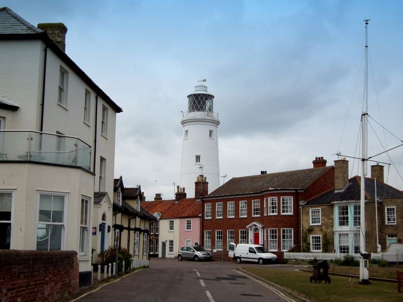
SOUTHWOLD
TM5076 STRADBROKE ROAD
588-1/7/131 (East side)
22/11/71 The Lighthouse
(Formerly Listed as:
The Lighthouse)
II
Lighthouse. 1892. Rendered and whitewashed brick; outbuilding
has slate roof.
EXTERIOR: tapering tower with single-storey outbuilding
attached to rear. Entrance in outbuilding. Tower has 2-light
casements at intervals, those to the top floor with canted top
lights. Top stage has moulded cornice below railed balcony and
lantern stage: glazed circular lantern. On tower front are the
Arms of the Corporation of Trinity House.
INTERIOR: not inspected.
(Jenkins AB: A Hundred Years of Southwold in Photographs:
Southwold: 1983-: 62; Buildings of England: Pevsner N &
Radcliffe E: Buildings of England: Suffolk, 2nd Edition:
Harmondsworth: 1974-: 434).
Listing NGR: TM5094276284
External links are from the relevant listing authority and, where applicable, Wikidata. Wikidata IDs may be related buildings as well as this specific building. If you want to add or update a link, you will need to do so by editing the Wikidata entry.


Other nearby listed buildings
