Approximate Location Map
Large Map »
Latitude: 53.5527 / 53°33'9"N
Longitude: -2.638 / 2°38'16"W
OS Eastings: 357825
OS Northings: 406424
OS Grid: SD578064
Mapcode National: GBR BW0C.N5
Mapcode Global: WH97R.GY0S
Plus Code: 9C5VH936+3Q
Entry Name: Bandstand
Listing Date: 11 July 1983
Grade: II
Source: Historic England
Source ID: 1384492
English Heritage Legacy ID: 484926
ID on this website: 101384492
Location: Mesnes Park, Bull Hey, Wigan, Greater Manchester, WN1
County: Wigan
Electoral Ward/Division: Wigan Central
Parish: Non Civil Parish
Built-Up Area: Wigan
Traditional County: Lancashire
Lieutenancy Area (Ceremonial County): Greater Manchester
Church of England Parish: Wigan All Saints
Church of England Diocese: Liverpool
Tagged with: Bandstand
This list entry was subject to a Minor Enhancement on 28 April 2021 to amend the description, reformat the text to current standards and add references to selected sources
SD50NE
24-1/2/42
WIGAN
MESNES PARK
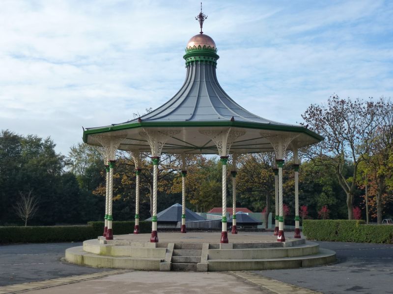
Bandstand
11/07/83
GV
II
Bandstand, manufactured 1891 by George Smith and Co of the Sun Foundry, Glasgow and probably installed in 1891 or 1892. Sandstone plinth, cast-iron columns, metal-clad wooden roof. Ten-sided plan. Single-storey, open-sided; cast-iron columns at the angles with fluted bases, twisted shafts and crocket capitals (in 1983 linked by a circular wooden beam attached to the inner faces, probably dating from 1927 and replacing earlier glazed timber shuttering); large pierced spandrel brackets springing from the capitals both laterally and forwards to carry the oversailing eaves of a strongly-swept roof which has a simple corona round a dome with renewed finial. The design’s pierced balustrades are absent.
INTERIOR has flat boarded ceiling.
Forms group with The Pavilion (qv)
Listing NGR: SD5782506424
External links are from the relevant listing authority and, where applicable, Wikidata. Wikidata IDs may be related buildings as well as this specific building. If you want to add or update a link, you will need to do so by editing the Wikidata entry.


Other nearby listed buildings
