Approximate Location Map
Large Map »
Latitude: 53.5409 / 53°32'27"N
Longitude: -2.638 / 2°38'16"W
OS Eastings: 357817
OS Northings: 405109
OS Grid: SD578051
Mapcode National: GBR BW0H.PD
Mapcode Global: WH97Y.G819
Plus Code: 9C5VG9R6+9R
Entry Name: Canal Cottages with Attached Boundary Wall
Listing Date: 8 December 1999
Grade: II
Source: Historic England
Source ID: 1384506
English Heritage Legacy ID: 484940
ID on this website: 101384506
Location: Wallgate, Wigan, Greater Manchester, WN3
County: Wigan
Electoral Ward/Division: Douglas
Parish: Non Civil Parish
Built-Up Area: Wigan
Traditional County: Lancashire
Lieutenancy Area (Ceremonial County): Greater Manchester
Church of England Parish: Wigan St James with St Thomas
Church of England Diocese: Liverpool
Tagged with: Cottage
SD50NE
24-1/2/55
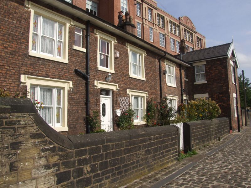
WIGAN,
POTTERY ROAD (South side),
Canal Cottages Nos 4 and 5, with attached boundary wall
GV II
Formerly known as: Canal House Nos 1 and 2 POTTERY ROAD.
Cottages, associated with Leeds-Liverpool Canal. Probably mid
to later C19. Brick, with slate roofs. T-plan formed by range
parallel to canal with crosswing at south end.
2 storeys, 3+1:1 windows. No.4, double-fronted and almost
symmetrical, has a square-headed doorway with overlight and
hood-mould, a sashed window above with margin panes and
similar hood-mould, flanked by tripartite sashes on both
floors all with hood-moulds (and a small inserted window to
the right of the upper left of these). No.5 continued to the
right has one similar tripartite sash on each floor, a doorway
in the angle with the wing, one window on each floor of the
re-entrant of this and one 2-light sashed window on each floor
of the gable. Shallow-pitched roofs with oversailing eaves and
verges; gable chimney at left end and ridge chimneys to both
ranges.
INTERIOR not inspected.
SUBSIDIARY FEATURE: the attached boundary wall to the front,
of coursed gritstone blocks with rounded coping, is
approximately 1.5m high, ramped up at the left end, and has a
gateway aligned with the front door of each cottage, each with
plain monolithic piers which have rounded tops; and to left of
the ramp a larger but similar gateway; to the left of which
the wall continues.
Forms part of interesting group with Trencherfield Mill (qv)
which towers above to the rear.
Listing NGR: SD5781705107
External links are from the relevant listing authority and, where applicable, Wikidata. Wikidata IDs may be related buildings as well as this specific building. If you want to add or update a link, you will need to do so by editing the Wikidata entry.


Other nearby listed buildings
