Approximate Location Map
Large Map »
Latitude: 51.499 / 51°29'56"N
Longitude: -0.0926 / 0°5'33"W
OS Eastings: 532498
OS Northings: 179508
OS Grid: TQ324795
Mapcode National: GBR RJ.CT
Mapcode Global: VHGR0.BLX7
Plus Code: 9C3XFWX4+HX
Entry Name: 26 and 28, Cole Street
Listing Date: 23 October 1995
Grade: II
Source: Historic England
Source ID: 1385401
English Heritage Legacy ID: 470794
ID on this website: 101385401
Location: Southwark, London, SE1
County: London
District: Southwark
Electoral Ward/Division: Chaucer
Parish: Non Civil Parish
Built-Up Area: Southwark
Traditional County: Surrey
Lieutenancy Area (Ceremonial County): Greater London
Church of England Parish: Southwark St George the Martyr with St Alphage and St Jude
Church of England Diocese: Southwark
Tagged with: Building
SOUTHWARK
TQ3279 COLE STREET
636-1/5/875 (South West side)
23/10/95 Nos.26 AND 28
II
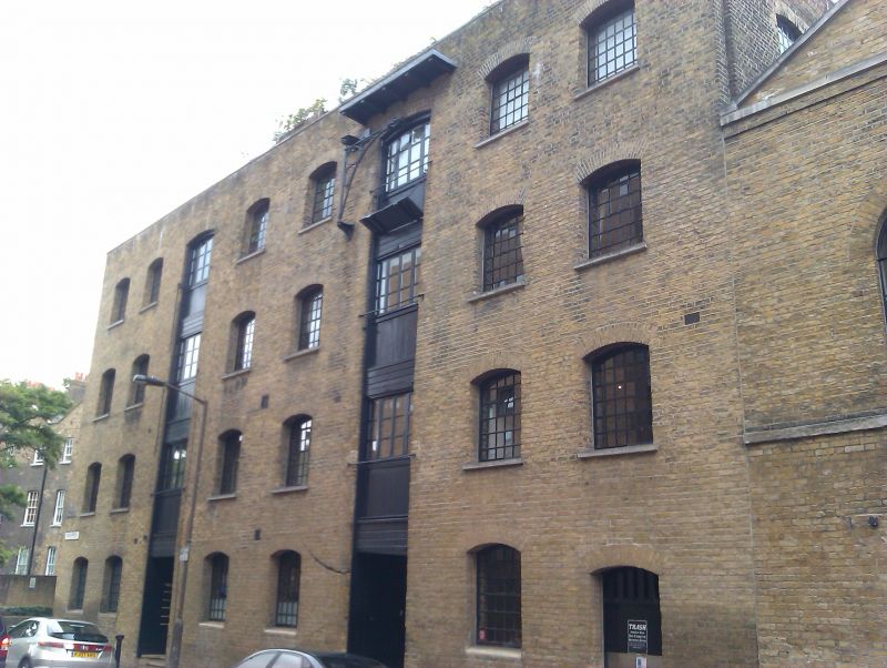
Warehouse. 1826-27. By William Chadwick, builder. Brick in
Flemish bond. Hipped roof of slate. Roughly rectangular in
plan, approx 27m to each long side.
EXTERIOR: 4 storeys. Long elevation has range of 8 windows,
the 3rd and 6th functioning as hoist ranges. Entrance to right
party wall. Short return has 3-window range articulated by
shallow brick arcade spanning first, 2nd and top floors. The
windows on the return have been rebuilt, but follow roughly
the plan of those on the long elevation and thus do not
compromise the structure's historic character. Ground floor of
the return is blind except for pair of small windows at lower
left. All openings segmental-arched; windows to long elevation
with original cast-iron lattice glazing. Glazing to hoist
range appears also to be original. C19 hoist arm to top of
right-hand hoist range.
Rear elevation has blind brick arcades similar to those on the
return, 5 in number.
INTERIOR: plan on original lease now in the Guildhall Library
shows an interior divided into 5 bays by slender uprights; the
latter are reported to be timber. The bays backing the hoist
ranges are slightly wider than the rest.
A good example of early C19 warehousing and remarkably
complete. Constructed as the large houses in Trinity Church
Square were being completed (qqv), it illustrates the rapid
transformation of the area from suburban to commercial use in
the 3rd decade of the C19.
(Merrick's Charity, Cole Street leases, 1817-1952: Ms
No.30254).
Listing NGR: TQ3249879508
External links are from the relevant listing authority and, where applicable, Wikidata. Wikidata IDs may be related buildings as well as this specific building. If you want to add or update a link, you will need to do so by editing the Wikidata entry.


Other nearby listed buildings
