Latitude: 51.4459 / 51°26'45"N
Longitude: -0.085 / 0°5'6"W
OS Eastings: 533174
OS Northings: 173618
OS Grid: TQ331736
Mapcode National: GBR HL.M6Y
Mapcode Global: VHGR6.GXXG
Plus Code: 9C3XCWW7+9X
Entry Name: Stella House
Listing Date: 27 September 1972
Grade: II
Source: Historic England
Source ID: 1385402
English Heritage Legacy ID: 470795
ID on this website: 101385402
Location: Dulwich Village, Southwark, London, SE21
County: London
District: Southwark
Electoral Ward/Division: Village
Parish: Non Civil Parish
Built-Up Area: Southwark
Traditional County: Surrey
Lieutenancy Area (Ceremonial County): Greater London
Church of England Parish: Dulwich St Barnabas
Church of England Diocese: Southwark
Tagged with: House
SOUTHWARK
TQ3373 COLLEGE ROAD
636-1/15/220 (East side)
27/09/72 No.11
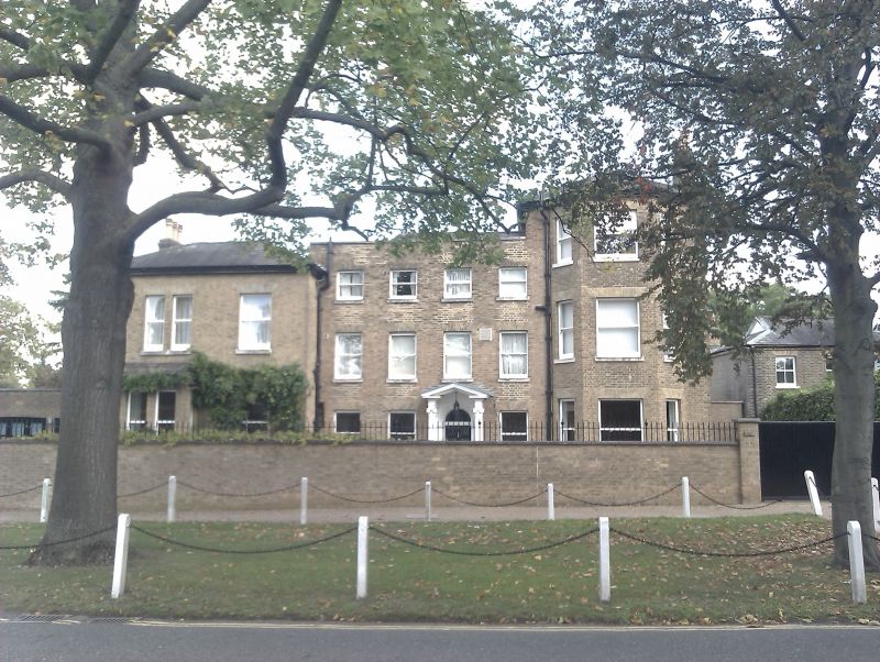
Stella House
II
Large house. Late C18-early C19 with later extensions either
side. Buff brick with hipped slate roof.
Original house 3 storeys, 4 bays with parapet and
open-pedimented timber Ionic porch; plain fanlight to
round-headed door with cornice head in round-arched recess.
Flat, gauged-brick arches to replacement sash windows.
Full-height canted bay to 3-storey right-hand extension.
2-storey, 2-bay extension to left with outer ground-floor bay
window.
INTERIOR: not inspected.
Listing NGR: TQ3317473618
External links are from the relevant listing authority and, where applicable, Wikidata. Wikidata IDs may be related buildings as well as this specific building. If you want to add or update a link, you will need to do so by editing the Wikidata entry.


Other nearby listed buildings