Latitude: 51.4424 / 51°26'32"N
Longitude: -0.0842 / 0°5'3"W
OS Eastings: 533244
OS Northings: 173230
OS Grid: TQ332732
Mapcode National: GBR HL.TQG
Mapcode Global: VHGRD.H0CL
Plus Code: 9C3XCWR8+X8
Entry Name: Oakfield
Listing Date: 30 June 1954
Grade: II
Source: Historic England
Source ID: 1385405
English Heritage Legacy ID: 470798
ID on this website: 101385405
Location: Dulwich Village, Southwark, London, SE21
County: London
District: Southwark
Electoral Ward/Division: Village
Parish: Non Civil Parish
Built-Up Area: Southwark
Traditional County: Surrey
Lieutenancy Area (Ceremonial County): Greater London
Church of England Parish: Dulwich St Barnabas
Church of England Diocese: Southwark
Tagged with: Building
SOUTHWARK
TQ3373 COLLEGE ROAD
636-1/15/223 (East side)
30/06/54 No.41
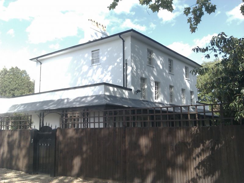
Oakfield
GV II
Detached house. 1721 with alterations and extensions. Stucco
with swept, hipped slate roof with deep eaves.
3 storeys, 5 bays (3 windows only at 2nd floor) with lower,
2-storey, hipped roof additions to east and west. Wooden
trellis verandah to 3 sides of ground floor. French windows
with margin lights on ground floor; sash windows with glazing
bars on upper floors.
INTERIOR: not inspected.
Listing NGR: TQ3324473230
External links are from the relevant listing authority and, where applicable, Wikidata. Wikidata IDs may be related buildings as well as this specific building. If you want to add or update a link, you will need to do so by editing the Wikidata entry.


Other nearby listed buildings