Approximate Location Map
Large Map »
Latitude: 51.4426 / 51°26'33"N
Longitude: -0.0844 / 0°5'3"W
OS Eastings: 533228
OS Northings: 173256
OS Grid: TQ332732
Mapcode National: GBR HL.TMS
Mapcode Global: VHGR6.HZ7Y
Plus Code: 9C3XCWV8+36
Entry Name: Outbuilding North West of Number 41 (Oakfield)
Listing Date: 30 June 1954
Last Amended: 17 September 1998
Grade: II
Source: Historic England
Source ID: 1385406
English Heritage Legacy ID: 470799
ID on this website: 101385406
Location: Dulwich Village, Southwark, London, SE21
County: London
District: Southwark
Electoral Ward/Division: Village
Parish: Non Civil Parish
Built-Up Area: Southwark
Traditional County: Surrey
Lieutenancy Area (Ceremonial County): Greater London
Church of England Parish: Dulwich St Barnabas
Church of England Diocese: Southwark
Tagged with: Appendage
SOUTHWARK
TQ3373 COLLEGE ROAD
636-1/15/224 (East side)
30/06/54 Outbuilding north-west of No.41
(Oakfield)
(Formerly Listed as:
COLLEGE ROAD
(East side)
Outbuilding adjoining No.41
(Oakfield))
GV II
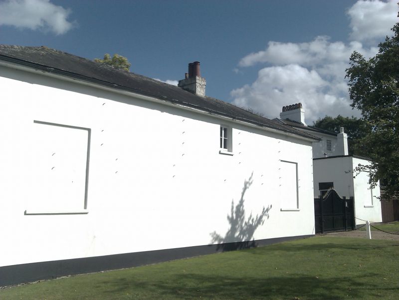
Detached outbuilding, now converted to dwelling. C18, altered.
Stucco with hipped slate roof with projecting eaves. Similar
style to Oakfield (qv).
Large garage door opening to ground floor. Irregular
fenestration, mainly sash windows with glazing bars. Elevation
to road mainly blind.
INTERIOR: not inspected.
Included for group value.
Listing NGR: TQ3322873256
External links are from the relevant listing authority and, where applicable, Wikidata. Wikidata IDs may be related buildings as well as this specific building. If you want to add or update a link, you will need to do so by editing the Wikidata entry.


Other nearby listed buildings
