Approximate Location Map
Large Map »
Latitude: 51.45 / 51°27'0"N
Longitude: -0.0858 / 0°5'8"W
OS Eastings: 533110
OS Northings: 174075
OS Grid: TQ331740
Mapcode National: GBR HL.725
Mapcode Global: VHGR6.GTH8
Plus Code: 9C3XFW27+2M
Entry Name: 50 and 52, Dulwich Village
Listing Date: 27 September 1972
Grade: II
Source: Historic England
Source ID: 1385477
English Heritage Legacy ID: 470876
ID on this website: 101385477
Location: Dulwich Village, Southwark, London, SE21
County: London
District: Southwark
Electoral Ward/Division: Village
Parish: Non Civil Parish
Built-Up Area: Southwark
Traditional County: Surrey
Lieutenancy Area (Ceremonial County): Greater London
Church of England Parish: Dulwich St Barnabas
Church of England Diocese: Southwark
Tagged with: Building
SOUTHWARK
TQ3374SW DULWICH VILLAGE
636-1/56/291 (West side)
27/09/72 Nos.50 AND 52
II
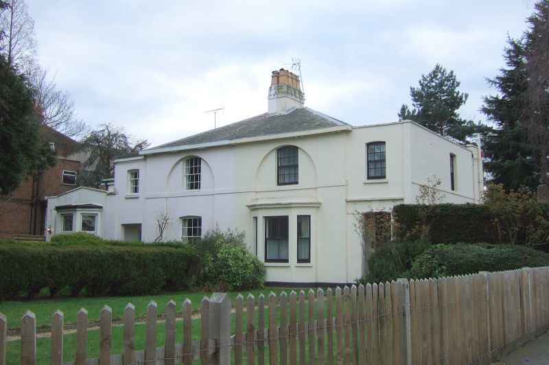
Pair of semi-detached houses. Early C19. Stucco with
low-pitched, hipped slate roof (over inner bays only) with
central stucco chimney.
2 storeys, 2 bays each. Entrances in outer bays, that to No.50
recessed behind segmental arch with keystone, that to No.52
recessed behind plain, square-headed opening. Segmental-headed
sash windows with glazing bars, those to main central section
within full-height, shallow round-arched recesses.
Ground-floor window to No.50 later adapted as canted bay.
1st-floor sill band.
INTERIOR: not inspected.
Listing NGR: TQ3311074075
External links are from the relevant listing authority and, where applicable, Wikidata. Wikidata IDs may be related buildings as well as this specific building. If you want to add or update a link, you will need to do so by editing the Wikidata entry.


Other nearby listed buildings
