Approximate Location Map
Large Map »
Latitude: 51.4505 / 51°27'1"N
Longitude: -0.0847 / 0°5'4"W
OS Eastings: 533184
OS Northings: 174130
OS Grid: TQ331741
Mapcode National: GBR HL.7BS
Mapcode Global: VHGR6.HS2X
Plus Code: 9C3XFW28+64
Entry Name: Unidentified Monument, Dulwich Old Burial Ground
Listing Date: 17 September 1998
Grade: II
Source: Historic England
Source ID: 1385504
English Heritage Legacy ID: 470903
ID on this website: 101385504
Location: Dulwich Village, Southwark, London, SE21
County: London
District: Southwark
Electoral Ward/Division: Village
Parish: Non Civil Parish
Built-Up Area: Southwark
Traditional County: Surrey
Lieutenancy Area (Ceremonial County): Greater London
Church of England Parish: Dulwich St Barnabas
Church of England Diocese: Southwark
Tagged with: Monument
TQ3374SW
636-1/56/319
SOUTHWARK
DULWICH VILLAGE
(East side)
Unidentified Monument, Dulwich Old Burial Ground
GV
II
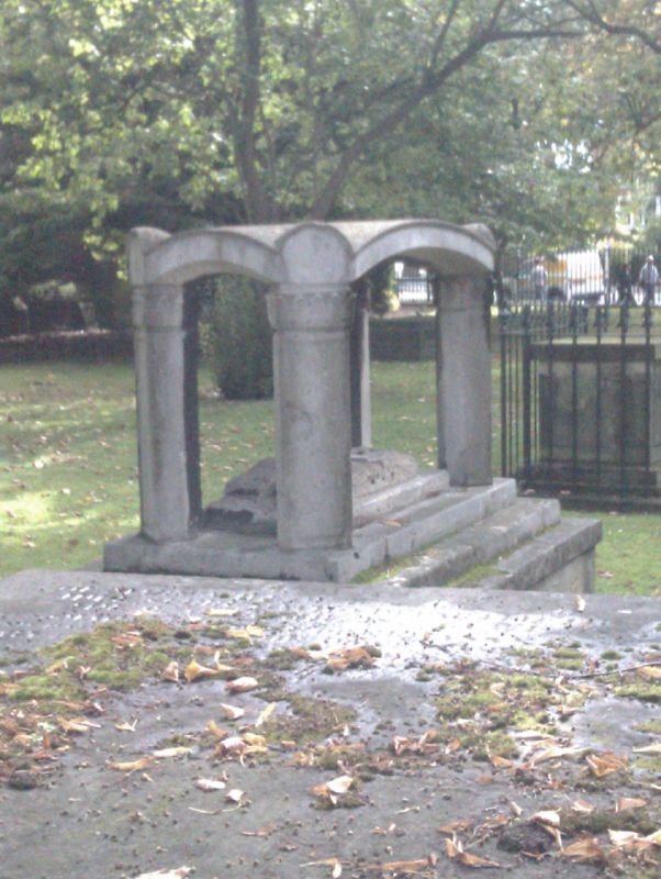
Tomb. Early C19. Stone on low brick plinth. Soanean in style.
Stylobate of 3 steps; shallow domed canopy supported by angled
corner piers with acanthus capitals. Under the canopy a broad
scrolled bracket resembling an open book. Marked C on plan,
located on south verge of site, immediately north of Flint
tomb (qv).
The burial ground, which was consecrated in 1616, was unusual
in not being adjacent to any church or chapel.
The monuments form a group with the C18 gates, walls and
railings to Dulwich Old Burial Ground (qv).
Listing NGR: TQ3318474130
External links are from the relevant listing authority and, where applicable, Wikidata. Wikidata IDs may be related buildings as well as this specific building. If you want to add or update a link, you will need to do so by editing the Wikidata entry.


Other nearby listed buildings
