Latitude: 51.4507 / 51°27'2"N
Longitude: -0.0852 / 0°5'6"W
OS Eastings: 533152
OS Northings: 174147
OS Grid: TQ331741
Mapcode National: GBR HL.77F
Mapcode Global: VHGR6.GSVS
Plus Code: 9C3XFW27+7W
Entry Name: Gates to Dulwich Old Burial Ground
Listing Date: 30 June 1954
Last Amended: 17 September 1998
Grade: II
Source: Historic England
Source ID: 1385505
English Heritage Legacy ID: 470904
ID on this website: 101385505
Location: Dulwich Village, Southwark, London, SE21
County: London
District: Southwark
Electoral Ward/Division: Village
Parish: Non Civil Parish
Built-Up Area: Southwark
Traditional County: Surrey
Lieutenancy Area (Ceremonial County): Greater London
Church of England Parish: Dulwich St Barnabas
Church of England Diocese: Southwark
Tagged with: Gate
TQ3374SW
636-1/56/320
30/06/54
SOUTHWARK
DULWICH VILLAGE
(East side)
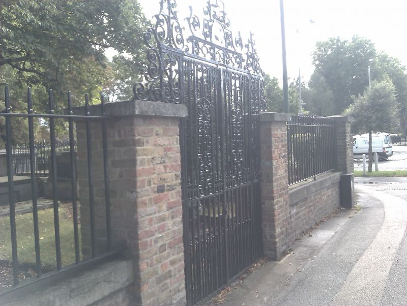
Gates to Dulwich Old Burial Ground
(Formerly Listed as:
DULWICH VILLAGE
(East side)
Gates, railings and boundary walls surrounding the old Burial Ground)
GV
II
Gates to cemetery. 1728. By G Buncker. Decorative wrought-iron
with elaborate overthrow.
Listing NGR: TQ3315274147
External links are from the relevant listing authority and, where applicable, Wikidata. Wikidata IDs may be related buildings as well as this specific building. If you want to add or update a link, you will need to do so by editing the Wikidata entry.


Other nearby listed buildings