Approximate Location Map
Large Map »
Latitude: 51.4705 / 51°28'13"N
Longitude: -0.0714 / 0°4'17"W
OS Eastings: 534047
OS Northings: 176379
OS Grid: TQ340763
Mapcode National: GBR XW.31
Mapcode Global: VHGR6.Q93K
Plus Code: 9C3XFWCH+6C
Entry Name: 32A and 32B, Elm Grove
Listing Date: 27 September 1972
Last Amended: 17 September 1998
Grade: II
Source: Historic England
Source ID: 1385515
English Heritage Legacy ID: 470914
ID on this website: 101385515
Location: Peckham, Southwark, London, SE15
County: London
District: Southwark
Electoral Ward/Division: The Lane
Parish: Non Civil Parish
Built-Up Area: Southwark
Traditional County: Surrey
Lieutenancy Area (Ceremonial County): Greater London
Church of England Parish: Peckham All Saints
Church of England Diocese: Southwark
Tagged with: Building
SOUTHWARK
TQ3476 ELM GROVE
636-1/12/329 (North side)
27/09/72 Nos.32A AND 32B
(Formerly Listed as:
ELM GROVE
(West side)
Nos.26-32 (Even))
GV II
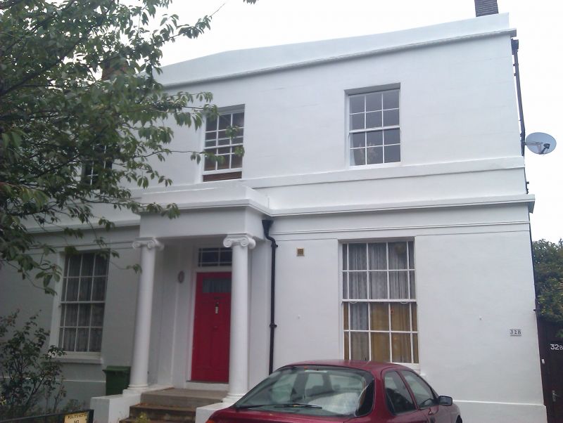
Detached villa. c1836. Stucco with low pitched slate roof
behind cornice and blocking course.
2 storeys, 3 bays. Double-fronted. Door with Ionic prostyle
porch, moulded string between floors continuing across porch
entablature as cornice. Plain reveals to sash windows with
glazing bars, those on ground-floor with margin lights;
1st-floor sill string.
INTERIOR: not inspected.
Listing NGR: TQ3404776378
External links are from the relevant listing authority and, where applicable, Wikidata. Wikidata IDs may be related buildings as well as this specific building. If you want to add or update a link, you will need to do so by editing the Wikidata entry.


Other nearby listed buildings
