Approximate Location Map
Large Map »
Latitude: 51.4979 / 51°29'52"N
Longitude: -0.0911 / 0°5'27"W
OS Eastings: 532605
OS Northings: 179384
OS Grid: TQ326793
Mapcode National: GBR RK.P7
Mapcode Global: VHGR0.CMQ3
Plus Code: 9C3XFWX5+4H
Entry Name: Surrey Dispensary
Listing Date: 17 September 1998
Grade: II
Source: Historic England
Source ID: 1385522
English Heritage Legacy ID: 470921
ID on this website: 101385522
Location: Southwark, London, SE1
County: London
District: Southwark
Electoral Ward/Division: Chaucer
Parish: Non Civil Parish
Built-Up Area: Southwark
Traditional County: Surrey
Lieutenancy Area (Ceremonial County): Greater London
Church of England Parish: Southwark Holy Trinity and St Matthew
Church of England Diocese: Southwark
Tagged with: Hospital Former hospital
SOUTHWARK
TQ3279 FALMOUTH ROAD
636-1/5/338 (North West side)
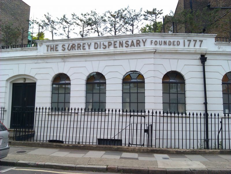
Surrey Dispensary
II
Dispensary. c1840. Stucco, scored to imitate banded
rustication and painted.
Single storey. Segmental-arched door to left with a narrow
round-arched light to the side; 3 round-arched windows to the
right, before rebated front wall, which angles back to form
join with No.42 Trinity Street (qv), and then 3 more
round-arched openings. Parapet over entrance with inscription
giving the date of the foundation of the Dispensary, in C20
lettering.
INTERIOR: not inspected.
HISTORICAL NOTE: founded in 1777, The Surrey Dispensary let
premises in Union Street in 1787. According to an 1840
prospectus its aims were 'visitations' to 'lying-in women',
the sick and injured. It was one of several such charities
operating in Victorian Southwark and is thought to be the
oldest in London.
Listing NGR: TQ3260579384
External links are from the relevant listing authority and, where applicable, Wikidata. Wikidata IDs may be related buildings as well as this specific building. If you want to add or update a link, you will need to do so by editing the Wikidata entry.


Other nearby listed buildings
