Approximate Location Map
Large Map »
Latitude: 51.4863 / 51°29'10"N
Longitude: -0.0918 / 0°5'30"W
OS Eastings: 532584
OS Northings: 178102
OS Grid: TQ325781
Mapcode National: GBR RP.JC
Mapcode Global: VHGR0.CW9Y
Plus Code: 9C3XFWP5+G7
Entry Name: 54, 56 and 58, Liverpool Grove
Listing Date: 17 September 1998
Grade: II
Source: Historic England
Source ID: 1385661
English Heritage Legacy ID: 471065
ID on this website: 101385661
Location: Walworth, Southwark, London, SE17
County: London
District: Southwark
Electoral Ward/Division: Faraday
Parish: Non Civil Parish
Built-Up Area: Southwark
Traditional County: Surrey
Lieutenancy Area (Ceremonial County): Greater London
Church of England Parish: Walworth St Peter
Church of England Diocese: Southwark
Tagged with: Building
This list entry was subject to a Minor Enhancement on 18 July 2023 to amend the description and to add historic background and selected sources
TQ3278
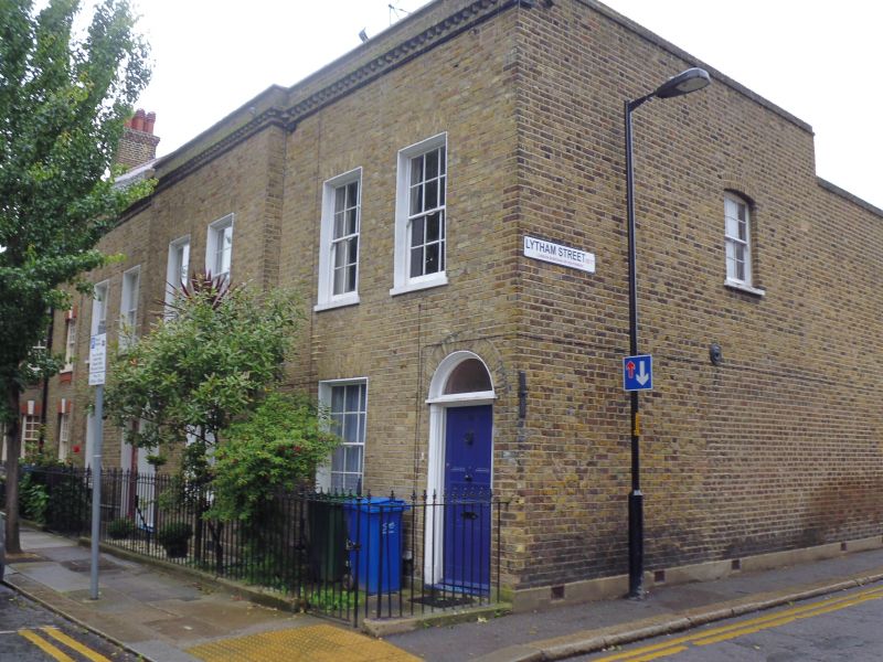
636-1/8/484
LIVERPOOL GROVE (South side) SOUTHWARK
Nos.54, 56 AND 58
GV II
Group of three terraced houses, early-C19.
MATERIALS: brick laid in Flemish bond; roof parapeted with a continuous band of cogged brick.
EXTERIOR: two storeys and two windows each. All entrances are round-arched with fanlight, the door flanked by quarter, fluted attached columns; 5-panel doors of an
original design. Entrances to Nos 56 & 58 paired. All windows flat-arched with gauged brick lintels and 6x6 sashes of an original design. The centre unit projects by two bricks' thickness from the side units.
INTERIOR: not inspected.
The terrace has group value with the Church of St Peter (listed at Grade I), its gates, gate piers, boundary walls and railings (listed at Grade II), and with 28-52 Liverpool Grove (listed at Grade II).
Listing NGR: TQ3258278092
The medieval village of Walworth is mentioned in the Domesday Book, comprising Walworth Manor House, 19 other households and a church. By the beginning of the C19, much of the area was still semi-rural with large tracts of rough pasture and market gardens behind houses fronting the streets. But in the first two decades of the C19 the population of the Parish of St Mary Newington (including the Manor of Walworth) grew rapidly from 14,847 to 44,526, and by 1901 it had reached 122,172. The growing influx of workers moving to the area gradually shifted Walworth from being a wealthy Georgian suburb to being a densely-populated working-class area, with much of the open land developed with terraced housing by the middle of the C19. The opening of the Walworth Road and Camberwell New Road railway stations in 1862 accelerated the construction of housing for workers who could now easily commute to central London, both on previously undeveloped land and on the sites of demolished early C19 houses. Much of the housing in the area was built speculatively by local builders and, later in the C19, by philanthropic organisations including the Guinness Trust and the Peabody Trust. Further redevelopment by the Ecclesiastical Commissioners for England in the Edwardian period in response to the continuing influx of working-class people resulted in the redevelopment of much of the Georgian housing on the Commissioners’ land south of Liverpool Grove. Much of the resulting Arts and Crafts style blocks built by the Commissioners with the expertise and guidance of Octavia Hill survives. In the second half of the C20 the area underwent another transformation with slum clearances and the development of large public housing schemes on the Aylesbury and Heygate Estates. The multiple phases of housing development through the C19 and C20 by different builders and organisations have resulted in a diversity of architectural styles and approaches to housing concentrated in a relatively small area in Walworth.
The Church of St Peter, constructed in 1823 to designs by Sir John Soane, was central to the development of the area east of Walworth Road in what is now the Liverpool Grove Conservation Area. Many of the street names including Trafalgar Road, Cadiz Street, Liverpool Street and Portland Street reflect their development soon after the end of the Napoleonic Wars; the Earl of Liverpool and the Duke of Portland were both Tory Prime Ministers during the last years of the wars. The land to the north and south of the church was originally part of the Rolls Estate. Liverpool Street (as it was then known) was laid out in 1827 to connect with the approach to the church from Walworth Road, but the row of houses known as Peacock Terrace (now 28-52 Liverpool Grove) along its south side were not constructed until 1842. A stone plaque on the east flank wall of Number 52 indicates that the houses were built by local builder Thomas Peacock, who lived in Beckford Row, Walworth Road. The completed development on Liverpool Grove is visible on Kelly’s Post Office Directory Map of London 1857, with a gap between numbers 52 and 54 to accommodate Little Liverpool Street extending to Elizabeth Street (now Lytham Street) to the south.
Peacock Terrace suffered bomb damage during the Second World War: a 1945 bomb damage map indicates that numbers 24 and 26 were damaged beyond repair and other houses in the terrace sustained varying levels of damage. Numbers 24 and 26 have since been rebuilt as facsimiles of the originals but are not included in this List entry. When the Survey of London published its volume on St Mary Newington in 1955 (see Sources), it reported that the parapet bore an inscription that read: PEACOCK TERRACE 1842. This has since been removed or covered over.
External links are from the relevant listing authority and, where applicable, Wikidata. Wikidata IDs may be related buildings as well as this specific building. If you want to add or update a link, you will need to do so by editing the Wikidata entry.


Other nearby listed buildings
