Approximate Location Map
Large Map »
Latitude: 51.5011 / 51°30'4"N
Longitude: -0.0729 / 0°4'22"W
OS Eastings: 533854
OS Northings: 179782
OS Grid: TQ338797
Mapcode National: GBR WJ.R1
Mapcode Global: VHGR0.PJ9L
Plus Code: 9C3XGW2G+FR
Entry Name: St Saviours Warehouse
Listing Date: 1 July 1983
Last Amended: 17 September 1998
Grade: II
Source: Historic England
Source ID: 1385889
English Heritage Legacy ID: 471308
ID on this website: 101385889
Location: Bermondsey, Southwark, London, SE1
County: London
District: Southwark
Electoral Ward/Division: Riverside
Parish: Non Civil Parish
Built-Up Area: Southwark
Traditional County: Surrey
Lieutenancy Area (Ceremonial County): Greater London
Church of England Parish: Bermondsey St Mary Magdalen, St Olave, St John and St Luke
Church of England Diocese: Southwark
Tagged with: Warehouse
SOUTHWARK
TQ3379 SHAD THAMES
636-1/5/680 (East side)
01/07/83 No.8
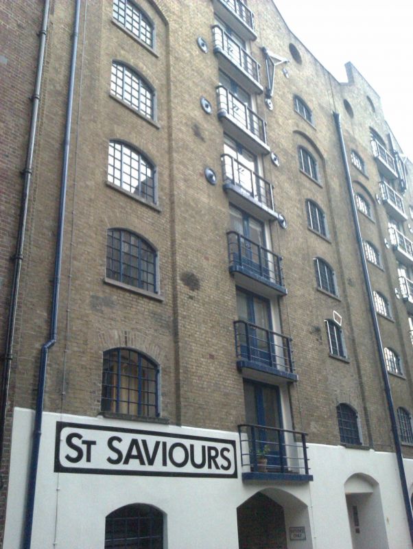
St Saviour's Warehouse
(Formerly Listed as:
SHAD THAMES
Christian's Warehouses, St Saviour's
Dock)
GV II
Pair of warehouses backing onto St Saviour's Dock, now flats.
c1850, rebuilt inside C20. Yellow stock brick with twin gables
rebuilt above 7th floor.
8 storeys, 3 bays each. Ground floors stuccoed with
segmental-arched openings. Segmental-arched panels to outer
bays of each rise from 1st to 5th floors and contain windows
with segmental arches, an extra similar window above on 6th
floor at each end. Segmental-headed hatch ranks to centre of
each front (now adapted as balconies) rising from 1st to 7th
floors. Small oculus in gables and 2 between hatch ranks at
7th floor. Similar dockside elevation.
INTERIOR: not inspected.
Good group value with other warehouses between St Saviour's
Dock and Shad Thames (qqv).
Listing NGR: TQ3385479782
External links are from the relevant listing authority and, where applicable, Wikidata. Wikidata IDs may be related buildings as well as this specific building. If you want to add or update a link, you will need to do so by editing the Wikidata entry.


Other nearby listed buildings
