Approximate Location Map
Large Map »
Latitude: 51.4992 / 51°29'56"N
Longitude: -0.0945 / 0°5'40"W
OS Eastings: 532362
OS Northings: 179524
OS Grid: TQ323795
Mapcode National: GBR QJ.XR
Mapcode Global: VHGR0.9LW3
Plus Code: 9C3XFWX4+M5
Entry Name: Trinity Arms Public House
Listing Date: 17 September 1998
Grade: II
Source: Historic England
Source ID: 1385957
English Heritage Legacy ID: 471377
Also known as: Trinity Arms
Trinity Arms, Borough
ID on this website: 101385957
Location: Southwark, London, SE1
County: London
District: Southwark
Electoral Ward/Division: Chaucer
Parish: Non Civil Parish
Built-Up Area: Southwark
Traditional County: Surrey
Lieutenancy Area (Ceremonial County): Greater London
Church of England Parish: Southwark Holy Trinity and St Matthew
Church of England Diocese: Southwark
Tagged with: Pub
SOUTHWARK
TQ3279 SWAN STREET
636-1/5/764 (North West side)
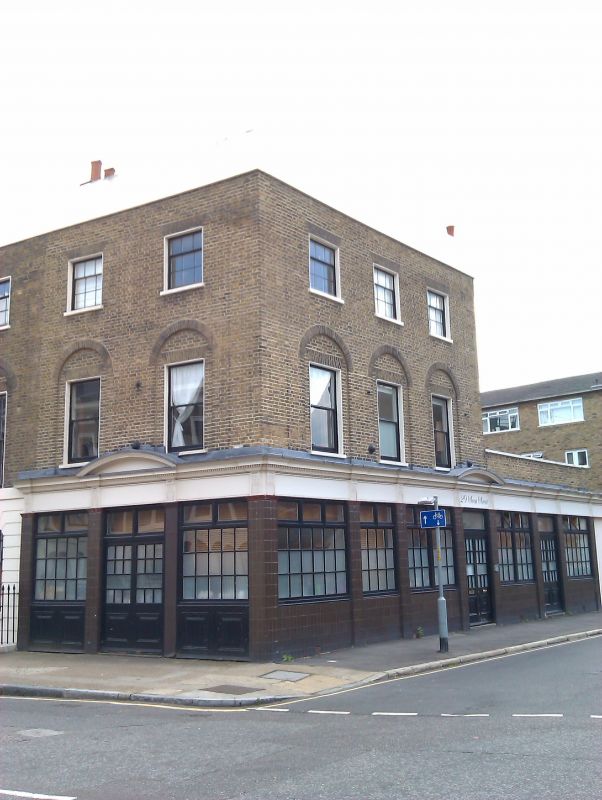
Trinity Arms Public House
GV II
House, now public house. 1810-1840. Brick in Flemish bond;
roof parapeted.
3 storeys over basement. 2-window range to Trinity Street and
3-window range to Swan Street, the 1st-floor windows set in
round-arched recesses; 2nd-floor windows with 3x6 sashes of
original design. All openings flat-arched.
INTERIOR: not inspected.
Built as part of the Trinity Square Development; converted to
public house in late C19 or early C20.
Included for group value.
Listing NGR: TQ3236279524
External links are from the relevant listing authority and, where applicable, Wikidata. Wikidata IDs may be related buildings as well as this specific building. If you want to add or update a link, you will need to do so by editing the Wikidata entry.


Other nearby listed buildings
