Approximate Location Map
Large Map »
Latitude: 50.3639 / 50°21'50"N
Longitude: -4.1426 / 4°8'33"W
OS Eastings: 247709
OS Northings: 53751
OS Grid: SX477537
Mapcode National: GBR RB8.RJ
Mapcode Global: FRA 2862.PXP
Plus Code: 9C2Q9V74+HX
Entry Name: Observation Tower by the Dome (Dome Not Included)
Listing Date: 9 November 1998
Grade: II
Source: Historic England
Source ID: 1386446
English Heritage Legacy ID: 473833
ID on this website: 101386446
Location: Hoe Park, West Hoe, Plymouth, Devon, PL1
County: City of Plymouth
Electoral Ward/Division: St Peter and the Waterfront
Parish: Non Civil Parish
Built-Up Area: Plymouth
Traditional County: Devon
Lieutenancy Area (Ceremonial County): Devon
Tagged with: Tower
PLYMOUTH
SX4753 THE HOE, Hoe
740-1/66/296 Observation Tower by the Dome (Dome
not included)
GV II
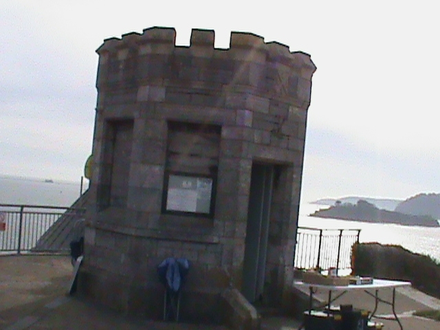
Observation tower in public park. Late C19. Granite plinth
otherwise Plymouth limestone brought to course and with
embattled parapet with cavetto parapet cornice. Small
octagonal plan with low chamfered doorway with planked door at
the landward end and sill string linking chamfered blind
window to each of the other elevations.
One of a good group of garden buildings on the Hoe, extended
and replanned in the 1880s.
(The Buildings of England: Pevsner N: Devon: London: 1989-:
665).
Listing NGR: SX4770953751
External links are from the relevant listing authority and, where applicable, Wikidata. Wikidata IDs may be related buildings as well as this specific building. If you want to add or update a link, you will need to do so by editing the Wikidata entry.


Other nearby listed buildings
