Approximate Location Map
Large Map »
Latitude: 50.3678 / 50°22'3"N
Longitude: -4.1363 / 4°8'10"W
OS Eastings: 248163
OS Northings: 54166
OS Grid: SX481541
Mapcode National: GBR RC9.9H
Mapcode Global: FRA 2872.6CN
Plus Code: 9C2Q9V97+4F
Entry Name: The Maritime Public House
Listing Date: 1 May 1975
Last Amended: 9 November 1998
Grade: II
Source: Historic England
Source ID: 1386455
English Heritage Legacy ID: 473842
Also known as: Maritime Inn
ID on this website: 101386455
Location: Barbican, Plymouth, Devon, PL1
County: City of Plymouth
Electoral Ward/Division: St Peter and the Waterfront
Parish: Non Civil Parish
Built-Up Area: Plymouth
Traditional County: Devon
Lieutenancy Area (Ceremonial County): Devon
Tagged with: Pub
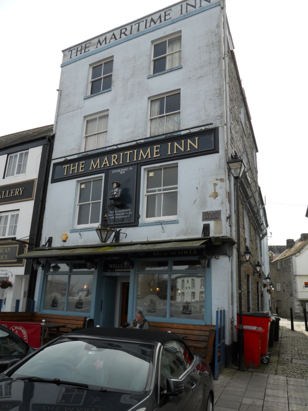
PLYMOUTH
SX4854SW THE PARADE, Barbican
740-1/62/91 (South side)
01/05/75 No.16
The Maritime Public House
(Formerly Listed as:
PARADE, Plymouth
No.16)
GV II
Shop premises, now a public house. Early C19. Incised stucco
to front, rubble to right-hand return and slate-hung to upper
floors; roof not visible behind parapet with string.
Double-depth plan.
4 storeys; symmetrical 2-window front. 4-pane hornless sashes,
possibly the original windows with intermediate glazing bars
removed. Ground floor has moulded fascia entablature over
original double shopfront with slender pilasters and later
transomed windows flanking a central doorway. Right-hand
return is a 2-window range with late C19 horned sashes, those
to lower floors with glazing bars.
INTERIOR: not inspected but may be of interest.
Listing NGR: SX4816354166
External links are from the relevant listing authority and, where applicable, Wikidata. Wikidata IDs may be related buildings as well as this specific building. If you want to add or update a link, you will need to do so by editing the Wikidata entry.


Other nearby listed buildings
