Latitude: 51.9009 / 51°54'3"N
Longitude: -2.0759 / 2°4'33"W
OS Eastings: 394873
OS Northings: 222489
OS Grid: SO948224
Mapcode National: GBR 2M4.XMD
Mapcode Global: VH947.YHX3
Plus Code: 9C3VWW2F+9J
Entry Name: 15 and 17, Clarence Street
Listing Date: 12 March 1955
Grade: II
Source: Historic England
Source ID: 1386858
English Heritage Legacy ID: 474270
ID on this website: 101386858
Location: Cheltenham, Gloucestershire, GL50
County: Gloucestershire
District: Cheltenham
Electoral Ward/Division: Lansdown
Parish: Non Civil Parish
Built-Up Area: Cheltenham
Traditional County: Gloucestershire
Lieutenancy Area (Ceremonial County): Gloucestershire
Church of England Parish: Cheltenham, St Mary with St Matthew
Church of England Diocese: Gloucester
Tagged with: Building
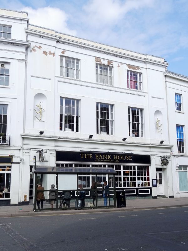
CHELTENHAM
SO9422SE CLARENCE STREET
630-1/13/272 (North side)
12/03/55 Nos.15 AND 17
GV II
Shops with flats over. c1825-34, shown on Merrett's Map of
1834, but not on the Post Office Map of 1820; later
alterations include c1970s glazing to ground floor. Stucco
over brick with concealed roof.
EXTERIOR: 3 storeys, 3 first-floor-window range plus outer
niches in breakforwards. Stucco detailing includes continuous
first-floor sill band; recessed panels above niches and long
panel across first-floor windows; continuous sill band to
second floor; architrave, frieze and cornice with blocking
course. Ground floor has Tower of Winds pilasters to original
entrances, now with c1970 glazing to left and glazed door to
right, with entablature. First and second floors have 3
tripartite sashes: 6/6 between 2/2, taller to ground floor.
INTERIOR: not inspected.
HISTORICAL NOTE: by 1844 this was the Cheltenham and
Gloucester Bank, the first joint stock bank in the town.
(Rowe G: Illustrated Cheltenham Guide 1850: Cheltenham:
1845-1969: 44-45 (ILLUS)).
Listing NGR: SO9487222495
External links are from the relevant listing authority and, where applicable, Wikidata. Wikidata IDs may be related buildings as well as this specific building. If you want to add or update a link, you will need to do so by editing the Wikidata entry.


Other nearby listed buildings